https://doi.org/10.36253/bsgi-7541
Depopulation, Ageing and Place Memory in Campania’s Inner Areas. A Focus on the Cilento Interno Pilot Area
Spopolamento, invecchiamento e memoria dei luoghi nelle Aree Interne della Campania: Un focus sull’area pilota Cilento Interno
Department of Political and Communication Sciences (POLICOM) - University of Salerno, Italy
E-mail: giovino@unisa.it; dbagnoli@unisa.it
Abstract. Over the past decade, Italy has faced a “demographic winter”, marked by significant territorial divisions both between the Central-Northern regions and the South and within central and inner areas, as defined by the National Strategy for Inner Areas (SNAI). This study investigates the processes of demographic decline and the geographies of aging in the inner areas of Campania, a region with pronounced demographic-settlement imbalances. The geostatistical analysis, supported by cartographic representations, is complemented by a qualitative field survey, aimed at exploring the contribution of the elderly to place memory and placetelling. Focusing on the SNAI project area “Cilento Interno”, a potential sixth Blue Zone in the world, the survey relies on in-depth interviews where the elderly, as custodians of local memory, recount their experiences and the changes they have witnessed. In our view, these narratives can contribute to a greater awareness of time and space, foster the construction of new imaginaries, and encourage new (self)representations of territories.
Keywords: depopulation, aging, place memory, inner areas, Campania.
Riassunto. L’“inverno demografico” che l’Italia sta sperimentando da circa un decennio si accompagna a marcate asimmetrie territoriali, sia tra Centro-Nord e Mezzogiorno, sia tra aree centrali e aree interne, così come definite dalla Strategia Nazionale per le Aree Interne (SNAI). Questo studio analizza i processi di declino demografico e le geografie dell’invecchiamento nelle aree interne della Campania, una delle regioni dove le faglie territoriali e gli squilibri demografico-insediativi si manifestano in modo più pronunciato. L’analisi geostatistica, supportata da rappresentazioni cartografiche, è integrata da un’indagine qualitativa sul campo, finalizzata a esplorare il contributo che gli anziani possono offrire alla memoria e narrazione dei luoghi. Assumendo come focus territoriale l’area pilota “Cilento Interno”, identificata come una potenziale sesta Blue Zone del mondo, l’indagine si avvale di interviste in profondità con gli anziani, custodi della memoria locale, che raccontano le loro esperienze e testimoniano i cambiamenti vissuti. Queste narrazioni, a nostro parere possono contribuire a una maggiore consapevolezza del tempo e dello spazio, favorire la costruzione di nuovi immaginari e nuove (auto)rappresentazioni territoriali.
Parole chiave: spopolamento, invecchiamento, memoria del luogo, aree interne, Campania.
Contents
2. The issue of inner areas in Italy: the reference framework
4. The qualitative survey: narrative voices from Inner Cilento
1) Familial background, work experiences and mobility
2) Lifestyle and social relations
3) Sense of places, local identity and transformations
4) Perceptions and perspectives on population dynamics and repopulation.
1. Introduction
Over the past decade, Italy has faced a “demographic winter”, marked by significant territorial divides, both between the Central-Northern regions and the South, and between central areas and inner areas, as defined by the National Strategy for Inner Areas (SNAI– Strategia Nazionale per le Aree Interne) (Barca et al. 2014).
Campania stands out as one of the regions where territorial inequalities are most evident, where demographic and settlement imbalances are most pronounced, and where the contrast between “flesh and bone” (Rossi-Doria 1958) and between filled and empty areas is historically more striking.
According to the updated SNAI classification (Istat 2022; Dipartimento Politiche di Coesione - NUVAP 2022), over half (290) of the 550 municipalities in Campania fall into the three clusters that make up the inner areas, with a significant presence of the most disadvantaged categories (123 peripheral and 42 ultra-peripheral municipalities). The dynamics of depopulation and aging, which have long affected these areas, are particularly unfavorable in the seven pilot inner areas (PIAs), characterized by a strongly regressive population structure and a significant presence of over-80s and, in some cases, centenarians (Regione Campania 2022; Formez PA 2022).
This paper examines the processes of demographic decline and the geographies of aging in these areas, with the aim of highlighting characteristics and spatial patterns. Methodologically, we adopt a mixed approach, combining quantitative and qualitative methods. The geostatistical analysis, supported by cartographic representations, is complemented by a “close-up” view (Cersosimo, Donzelli 2020, 8), as advocated by the Manifesto “Riabitare l’Italia” (Repopulating Italy), a view that aims to explore, through a qualitative field survey, the contribution that the elderly can offer to place memory and placetelling (Pollice 2022). For this purpose, we conducted 20 in-depth interviews in the pilot area “Cilento Interno”, a potential candidate to become the sixth blue zone in the world. In these interviews, the elderly, as custodians of the local memory, recount the places they have lived in and the changes they have witnessed. The guiding idea is that such narratives can generate a greater awareness of time and place and foster the shaping of new imaginaries and new territorial (self)representations, or, in the words of Italo Calvino (1967, 239) can help “to find in the ancient the ways to understand the new”.
The paper is structured as follows: section 2 introduces the issue of depopulation in Italy’s inner areas, providing a brief overview of relevant studies and policy documents; section 3 presents a context analysis of the regional territory, aimed at mapping the different geographies of depopulation and aging, with a focus on the SNAI seven pilot areas; section 4 presents the results of the qualitative field investigation carried out from March to May 2024; finally, section 5 provides concluding reflections.
2. The issue of inner areas in Italy: the reference framework
The issue of depopulation in Italy’s inner areas has a rich and complex history, spanning over a century. It is beyond the scope of this paper to fully cover the extensive scientific and public debate surrounding this topic. However, we can identify some historical phases that have characterized the phenomenon, each associated with different policies and varying conceptualizations of the geographical areas in question.
In fact, the notion of “inner areas” is neither uniform nor static: it has evolved over time, intersecting with the concepts of mountain and marginal rural regions (Iommi, Marinari 2017). These areas have been described from time to time as disadvantaged, peripheral, fragile, areas of abandonment, empty spaces, or “bone territories,” to mention just a few of the terms commonly used in the literature1.
The historical roots of the demographic crisis in these areas stretch from the second half of the 19th century to the early 20th century. During this period, the policies of the new unified Italian state, reinterpreting the territory through a liberal lens, encourage the migration of inhabitants from the most peripheral mountainous areas to the valleys. The resources of mountains are exploited to meet the needs of urban central areas, first through logging and then using water courses for hydroelectric power production, with limited benefits for local communities (Biasillo 2018; Sonnino 1975). At this early stage, depopulation is mitigated by positive natural population growth, while political attention focuses primarily on addressing the risk of landslides and floods exacerbated by the reduction of forest area2.
The exodus intensifies in the decade 1901-1911, with 42% of Italian municipalities experiencing population decline, as documented in Mortara’s 1912 essay titled “L’incubo dello spopolamento” (The Nightmare of Depopulation). Although this trend slows between the two world wars, life in the most remote mountain areas remains extremely challenging. This is evidenced by the first large-scale scientific survey on the Italian mountains, conducted in the 1930s by the Committee for Geography of the National Research Council and the National Institute of Agricultural Economics (Comitato per la geografia del CNR e INEA 1938). Led by Giusti and Toniolo (Toniolo 1930; Almagià 1932; Giusti 1930), this survey employs both quantitative and qualitative methods, including questionnaires administered to residents. The findings reveal a “latent malaise” among the populations of the Alpine and Apennine regions3, due to both cultural and psychological factors (particularly the allure of urban lifestyles) and socioeconomic discomfort. Significant importance is attributed to the lack of healthcare, education, and transport services, precisely the three types of essential collective services that underpin SNAI.
Until the end of the Second World War, depopulation appears to be mainly a mountain issue, affecting the Alpine regions. The situation changes in the years of the “economic miracle”. The extraordinary development experienced by the country between 1948 and 1973 fosters a new intense phase of exodus, exacerbating the long-standing imbalances between the North and South. This period sees a territorial extension of depopulation: hilly areas and the most remote countryside also begin to be abandoned4, with unprecedented intensity, especially in the South. Studies by Manlio Rossi Doria (1958; 2003) investigating southern rural areas bear witness to this. He coins the metaphor of the “flesh” and “bone” to describe the agricultural landscape of the South, with 12% labeled as “flesh”, representing flat and coastal areas with access to infrastructure and markets, and 88% categorized as “bone”, representing less accessible mountainous and hilly areas, the sacrificed victims of a modernity disrespectful of traditions and rural life.
The 1970s and 1980s witness a surge in studies and research focused on inner areas and territorial imbalances at both regional and national levels (Dematteis 1967; Filangieri 1975; Sonnino et al. 1977). A study by Di Salvo in 1979, reveals that 65% of Italy’s territory is classified as inner, disadvantaged, rural, or peripheral, with a strongly asymmetric distribution: 36% in the North, 18% in the Center, and 46% in the South. This asymmetry is further reinforced by two new phenomena in the 1970s: the slowdown of demographic growth in large cities (Vecchio 1989; Dematteis, Bonavero 1997) and the partial recovery of the Northern mountainous areas.
Two significant studies emerge in the 1980s: the Inner Areas Project carried out by Formez (1981), which investigates territorial imbalances in two regions - Campania and Calabria-, deemed representative of Southern Italy’s phenomena, and the research conducted by the Working Group for the Revaluation of Marginal Areas (GRAM-Gruppo di lavoro per la Rivalorizzazione delle Aree Marginali) of the Italian Geographers Association, coordinated by Dematteis. The first of the three volumes published (Cencini, Dematteis, Menegatti 1983) presents regional case studies which interpret marginality/peripherality according to different theoretical-methodological approaches.
Simultaneously, political attention to the issue grows. Policies targeting mountainous areas and depressed areas of the South are introduced. For the former, after the disappointing results of the Mountain Framework Law (L. 991/1952), a new framework law (L. 1102/71) is enacted, establishing Mountain Communities as territorial governance bodies responsible for implementing a multi-year development program funded by a National Fund (albeit limited). The Special Project 33 for the Inner Mezzogiorno, initiated within the extraordinary intervention for the South (L.183/76), aims primarily at supporting the agro-industrial and livestock sectors but also at promoting craftsmanship and tourism (Quaderni della Cassa per il Mezzogiorno 1981). This initiative, which also supports the reconstruction program of the 1980 earthquake-affected areas (Irpinia in Campania), concludes in 1993, giving way to the era of negotiated planning and integrated projects5.
In the 1990s and 2000s, the problem of inner areas becomes particularly dramatic. While at the national level the demographic balance remains positive primarily thanks to foreign immigration, inner and mountainous areas face a renewed acceleration of depopulation. This trend predominantly affect the South, where the natural balance (modest or negative) can no longer offset the exodus of residents (Del Panta, Detti 2019; Reynaud, Miccoli 2016). Conversely, several previously depopulated municipalities in the Northern mountainous regions experience population growth, attracting returnees and new residents, especially in the Alpine area (Varotto 2000; Corrado 2010; Dematteis 2011).
The recessionary crisis of 2008-2014, along with a contraction of public spending, further deepens North-South imbalances and the center-periphery divide (Ministro per il Sud e la Coesione Territoriale 2020). The abandonment of the “bone” territories is inevitably accompanied by intense population aging, which poses social, economic, and environmental sustainability challenges in the less developed contexts of Southern Italy.
In this difficult context, Fabrizio Barca and his working group make a significant contribution to the debate, leading to the development of the National Strategy for Inner Areas (Barca et al. 2014; Barca 2015). Inspired by Barca’s place-based approach proposed for European cohesion policies (Barca 2009), the SNAI rejects the classic center-periphery dichotomy and proposes a polycentric and innovative reading of inner areas. According to this approach, these struggling territories, marked by roughness, remoteness, and depopulation, have some “latent development factors” stemming from their strong identity and the availability of unused territorial capital, including ecosystem services, natural, cultural, cognitive, and social resources. Activating this potential requires tailored, bottom-up valorization policies that address the specific needs of local communities.
Operationally, the NUVAP-Nucleo di Valutazione e Analisi per la Programmazione (Nucleus of Evaluation and Analysis for Planning) employs a functional approach to identify inner areas based on their distance from centers of supply (classified as poles and inter-municipal poles) of essential services, namely health, education, and mobility6. Municipalities, other than poles and inter-municipal poles, are classified into four categories based on their distance (measured in travel time) from the nearest supply center: belt (up to 27.7 minutes), intermediate (27.7 to 40.9 minutes), peripheral (40.9 to 66.9 minutes), and ultra-peripheral (over 66.9 minutes). The last three categories -intermediate, peripheral, and ultra-peripheral- are classified as inner areas, encompassing over 3,800 municipalities, which account for approximately 60% of Italy’s territory and house about 13.3 million residents. These municipalities are predominantly located in the South, hosting over half of the inner areas’ population, a share that rises to 63% when considering only peripheral and ultra-peripheral municipalities (Svimez 2023).
The SNAI has revived interest in inner areas, as evidenced by the extensive literature produced in recent years, which cannot be fully covered here. Noteworthy, however, is the rich body of studies carried out by the “Riabitare l’Italia” association (De Rossi 2020; Lucatelli et al. 2022). Contrasting the prevalent urban-centric view, these multidisciplinary studies, which found a synthesis in the “Manifesto per riabitare l’Italia” (Cersosimo, Donzelli 2020), propose to reverse the perspective, embrace diversity as a value, and bring the margins back to the center of policy discussion (Carrosio 2019).
3. Demographic decline and aging geographies in Campania: a focus on the seven Pilot Inner Areas (PIAs)
After sixty years of demographic growth, the population of Campania begins to rapidly decline in 2012, losing over 237,000 inhabitants between 2011 and 2023, a decline due to both components of demographic dynamics: a negative natural growth rate, ongoing since 20147, along with significant migratory movements toward other parts of the country, which are not offset by positive net migration from abroad8.
As noted by Svimez (2023, 20), “Campania retains the primacy among southern regions with the largest demographic outflows, both toward the Central-Northern regions and abroad”. Most outbound migrants are young people with medium to high education levels9, in contrast to inbound flows. This depletion of highly educated human capital is likely to have a disruptive effect on the socio-economic system in the short term.
According to the latest Istat report (2024), in just over two decades (2002-2023), the number of young people aged 18 to 34 has fallen by over 365,000, reducing their share of the total population from 26% to 19.8%. While Campania remains the youngest region in Italy, the indices of population structure have significantly worsened: between 2002 and 2023 the aging index and the elderly dependency ratio have increased from 77.2% to 148.6% and from 48.7% to 52.1% respectively, while the average age of the population has reached almost 44 years in 2023, 6.1 years more than in 2002.
In other words, a worrying generational imbalance is emerging, which is expected to deepen in the near future. Istat’s forecasts suggest an acceleration of ongoing processes for Campania and the entire South. Based on the “median” probabilistic scenario, by mid-century, the region’s population is projected to shrink to 4.7 million residents -nearly 1 million fewer than in 2022- with over a third of individuals over 64 years old. This would result in a ratio of 304 elderly individuals for every 100 young people, a structural dependency ratio of 83% (+31 percentage points compared to 2022), and an average population age of 50.4 years.
In this context of demographic decline and aging, the most alarming data concerns the growing disparities between central areas and inner areas (IAs), as defined and identified by SNAI.
Figure 1 shows the SNAI mapping (in the two programming cycles), compared with two other territorial classifications. The first, from Istat, is based on geomorphological characteristics, namely coastal proximity and altimetric zones (mountain, hill, and plain) of the municipalities, while the second is the LEADER territorialization adopted by the Rural Development Plan (PSR) 2014-2020 and the more recent Complementary Regional Development Plan 2023-2027 (Del Giudice, Olivieri 2023), which divides the municipalities into four types of rural macro-areas, according to various variables, such as the incidence of agro-forestry area, population density, altimetric bands.
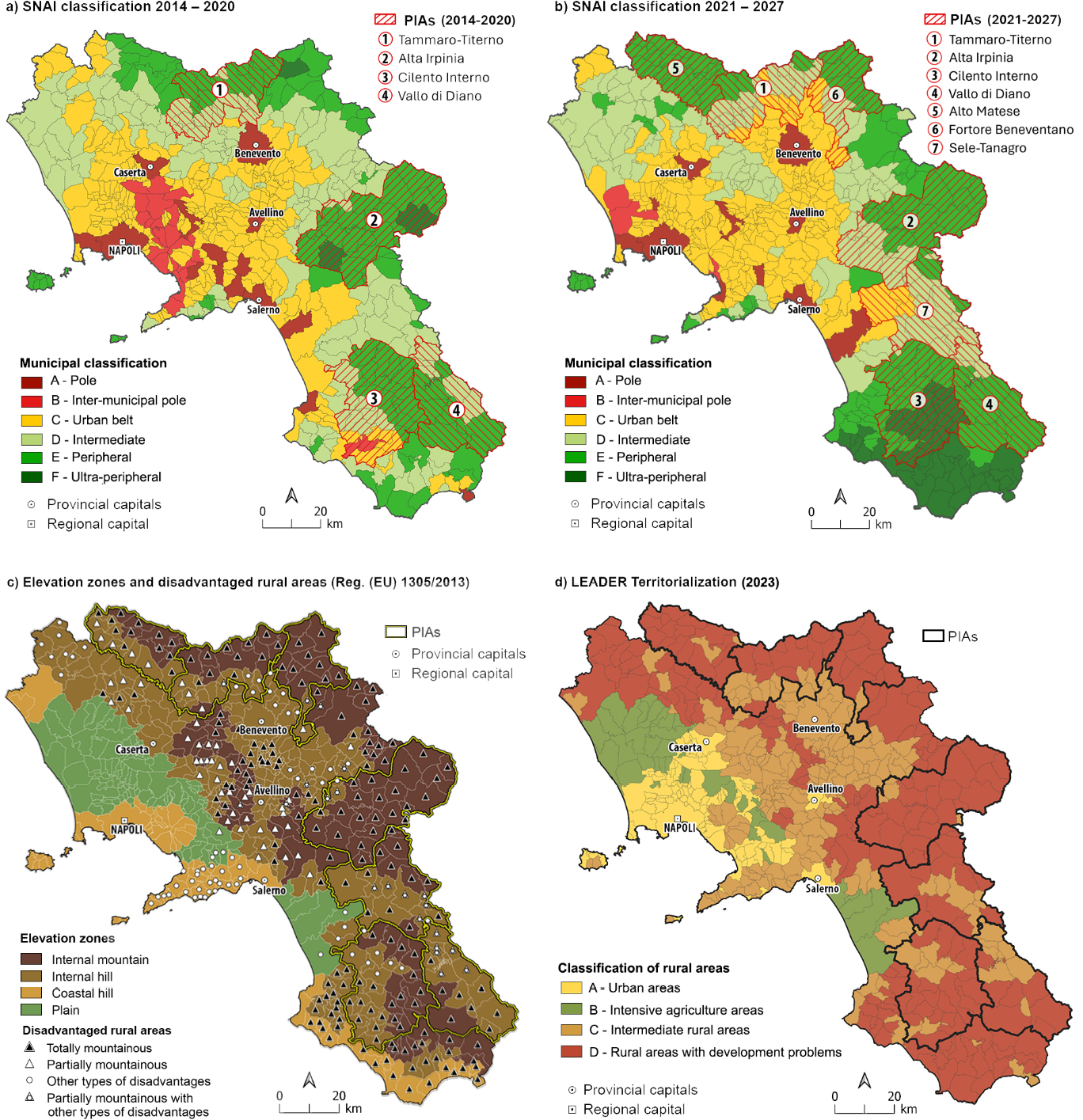
The comparison of the two SNAI maps (Figs. 1a and 1b) shows how the geography of these areas has changed between the two planning cycles. The number of municipalities classified as inner areas rises to 290, an increase of 20 since 2014. Their composition shifts significantly: intermediate municipalities decrease (-36), while ultra-peripheral areas see a substantial increase from 3 to 42, all located in the Salerno area. Even peripheral areas expanded from 106 to 123. This reclassification is closely related to the “disappearance of 25 supply centers”, as the number of poles and inter-municipal poles declines from 40 to 15, resulting in cascading effects on the classification of other municipalities10. Among the 550 municipalities in Campania, only 62.4% retain the same classification as in 2014 (343 municipalities). Approximately 10% improve their position by moving to a higher category (54 municipalities), while 27.8% are downgraded (153 municipalities). In many cases, the shift occurs between contiguous or closely related classes, but some municipalities regress by several positions compared to 2014. For instance, Sapri drops from category A to F, Agropoli moves from A to E, and both Vallo della Lucania and Castelnuovo Cilento from category B to E.
Overall, inner areas comprise 17.2% of the population and cover 66.4% of the regional territory, which partially corresponds to the mountainous or disadvantaged rural areas identified in the LEADER program (Figs. 1c and 1d). Notably, only 36.5% of the territory classified as inner is mountainous, encompassing 105 municipalities, mostly peripheral and ultra-peripheral). Mountain municipalities closer to urban poles (23 belt municipalities) are excluded. In both inner and central areas, hill municipalities predominate, representing 59.7% and 54.2% of the two types of areas, respectively.
The map also highlights municipalities falling within disadvantaged areas according to European regulations (Reg. EU 1305/2013), which include mountain areas, as well as two other types of disadvantaged areas (areas with natural constraints other than mountain areas and areas with specific constraints). Only 10 municipalities in the inner pilot areas lack any form of disadvantage. Generally, there is a good correspondence between peripheral and ultra-peripheral inner areas and disadvantaged areas, particularly mountainous ones. The latter, however, also affect many belt municipalities, with notable concentration in the Provinces of Avellino and Benevento.
The LEADER territorialization also shows partial intersections with the SNAI classification: 59% of inner municipalities and 32 belt municipalities fall into category D, which includes the most disadvantaged hilly and mountainous areas with low population density and a less dynamic economic system. Rural areas in category C described as “partially urbanized with intermediate development” are more prevalent in central areas than in inner areas (98 municipalities versus 11). A not entirely negligible proportion of inner municipalities belong to category A, designated as “urban and peri-urban areas” (including 9 municipalities located on islands or the Amalfi coast), and category B, labeled as “rural areas with intensive agriculture” (mainly located in the province of Caserta), confirming the non-overlapping of these territorializations based on different criteria and approaches11.
From a demographic perspective, the imbalances between central and inner areas are pronounced, a situation that becomes particularly evident in the seven SNAI pilot areas, which are the focus of the following analysis.
Table 1 summarizes some basic data related to these areas (hereafter PIAs, inner pilot areas), encompassing 141 municipalities and 29.1% of the regional territory.
| Pilot Inner Areas | Municipa- lities number |
Class E and F municipal. |
Surface area sq. km |
Population 2023 | Density 2023 (inh./sq.km) |
Population change (%) 1981-2023 | Aging index 2023 |
|---|---|---|---|---|---|---|---|
| Alta Irpinia | 25 | 17 | 1,118.0 | 57,320 | 51.3 | -29.0 | 252.3 |
| Alto Matese | 17 | 17 | 534.6 | 36,745 | 68.7 | -12.4 | 224.3 |
| Cilento Interno | 29 | 28 | 949.4 | 44,918 | 47.3 | -24.1 | 257.6 |
| Fortore Beneventano | 12 | 7 | 519.7 | 25,315 | 48.7 | -29.7 | 279.0 |
| Sele Tanagro | 19 | 3 | 784.9 | 55,737 | 71.0 | -4.7 | 183.6 |
| Tammaro-Titerno | 24 | 3 | 677.1 | 59,211 | 87.4 | -15.8 | 233.5 |
| Vallo di Diano | 15 | 11 | 725.3 | 56,433 | 77.8 | -11.0 | 203.6 |
| Total PIAs | 141 | 86 | 5,309.1 | 335,679 | 63.2 | -18.2 | 218.1 |
| Inner Areas | 290 | 165 | 9,079.4 | 964,343 | 106.2 | -6.3 | 198.1 |
| Central Areas | 260 | 0 | 4,591.6 | 4,645,193 | 1,011.7 | 1.3 | 139.9 |
Alta Irpinia is the largest PIA and one of the least densely populated. In contrast, Fortore Beneventano, a newly established pilot area corresponding to the homonymous mountain community, is the smallest (of both surface area and number of municipalities. It also records the highest aging index and the most significant demographic decline from 1981 to 2023.
Cilento Interno also holds several negative distinctions, being the PIA with the lowest demographic density and the highest average age (50.9 years). Among its 29 municipalities, 15 are classified as peripheral and 13 as ultra-peripheral, making it the only pilot area to host this category. In comparison, the PIAs Sele Tanagro and Tammaro-Titerno include a very small number of peripheral municipalities.
Disaggregating and mapping data at the municipal level, territorial disparities become more apparent (Fig. 2). A total of 170 municipalities do not exceed the threshold of 100 inhabitants per square kilometer, with 83 municipalities falling below 50 inhabitants per square kilometer. The lowest densities are found in Valle dell’Angelo and Corleto Monforte (6.1 and 9 inhabitants per square kilometer, respectively), both located within the Cilento Interno PIA. Conversely, only 8% of inner municipalities (mostly coastal) have densities above the regional average.
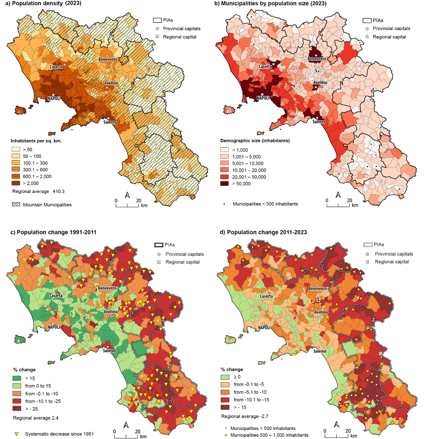
It is interesting to observe the demographic size of municipalities (Fig. 2b): those with less than 5,000 inhabitants account for nearly 72% of inner municipalities, 237 out of 290. In the pilot areas, the share of small municipalities rises to 83% of the total: 87 municipalities (almost half with less than 1,000 inhabitants) located mostly in the outermost mountainous areas. Only Campagna in the Sele Tanagro PIA and Sala Consilina in the Vallo di Diano PIA exceed 20,000 inhabitants. Cilento Interno is once again the PIA that concentrates the smallest municipalities (featuring 15 with less than 1,000 inhabitants), followed by Alto Matese and Alta Irpinia, each with 6 municipalities.
Since the 1990s, most inner areas have faced intense depopulation (Fig. 2c), especially in the most remote and hostile territories, largely corresponding to peripheral and ultra-peripheral municipalities (Cersosimo, Donzelli 2000; Matarazzo 2020). Between 1991 and 2011, the PIAs lose 9.5% of their population (-37,000 residents), with the highest average values in Fortore Beneventano and Alta Irpinia (-15.8% and -15.7%, respectively). As illustrated on the map, in 89 municipalities the decline starts in the 1950s and continues uninterrupted to the present day.
From 2011 onward, the demographic crisis in these marginal territories further accelerates (Fig. 2d), driven by a negative net migration and, more significantly, by the enormous imbalance between sharply declining birth rates and continuously increasing death rates, due to population advanced age, along with external shocks, such as the pandemic. The pilot areas in Campania lose over 33,000 inhabitants in the period 2011-2023, equivalent to a 9% population decline, compared to the regional average of -2.7%.
In these peripheral areas, the birth rate falls sharply, and young people leave, triggering a cumulative spiral that will inevitably lead to the desertification of the smallest and least serviced municipalities. There is indeed a dramatic inverse correlation between the size of municipalities and demographic regression. As Cersosimo and Licursi (2023, 13-14) observe, this trend worsens in the last two decades due to what they term “public policies of institutional Darwinism”. The authors argue that “the single-minded thinking of optimal efficient size” penalizes small municipalities and sparsely populated areas, by imposing quantitative standards (the dictatorship of the tot) for public services. This approach results in the withdrawal of essential collective services from demographically undersized territories, forcing municipalities into purpose aggregations (authors’ italics) in the name of efficiency.
The great tragedy of depopulation in inner areas is accompanied by the equally burdensome problem of aging. Decades of low birthrates and youth exodus create a major generational imbalance, a shift toward the elderly cohorts at the expense of the young and children, which in turn fuels new outbound flows. As studies by Reynaud and Miccoli (2023) clearly show, there is a bidirectional relationship between depopulation and aging. The exodus of young people negatively impacts reproductive rates, leading to a predominance of the elderly, both in absolute terms and relative to the rest of the population. Living in an aging context that neglects the needs of the youth increases their propensity to emigrate, especially in economically depressed territories.
Figure 3 shows the progressive senilization of the population and the resulting imbalance in the generational pyramid associated with demographic shrinkage. The proportion of elderly people (Fig. 3a) is high in all the inner areas, but reaches the highest levels in the PIAs, particularly in Fortore Beneventano and Cilento Interno. In these areas there are municipalities, such as Castelvetere in Val Fortore, Campora and Valle dell’Angelo, where the share of the elderly populations exceeding 40%, with significant proportions of octogenarians (19.1%, 17% and 18.7% of the population, respectively).
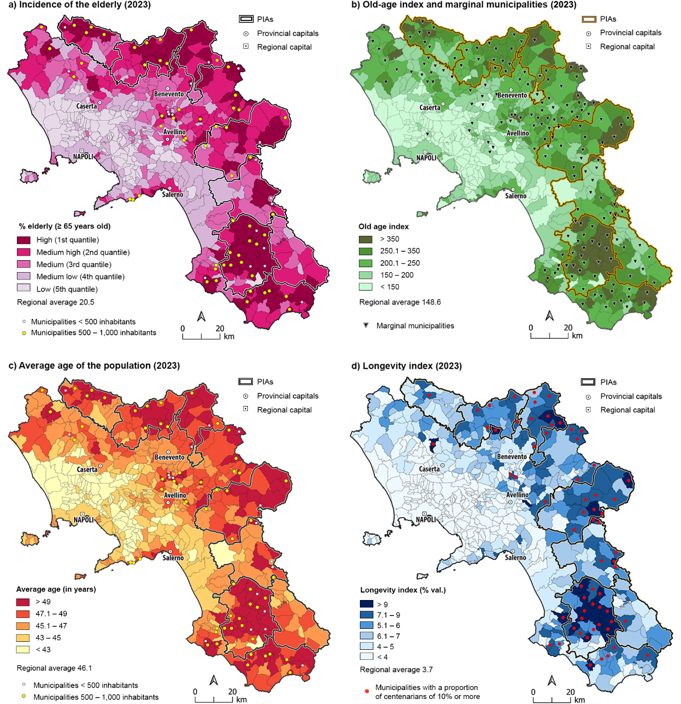
The old-age index, i.e. the ratio of young people to elderly, shows a similar spatial distribution (Fig. 3b). In the inner areas, the average value is 198 elderly individuals for every 100 young people. This figure rises significantly in the pilot areas, reaching an average of 218.1%. Fortore Beneventano and Cilento Interno again lead, with exceptionally high ratios of 279% and 257.6%, respectively. Notably, seventeen municipalities have an index exceeding 500%, with the highest recorded value of 1,285.7% in Valle dell’Angelo, where only 10 under-14-year-olds reside. Here, the age structure of the population takes the shape of a perfect inverted pyramid, illustrating a demographic shift in which aging occurs “from below”, by subtraction of young people, as highlighted in the Svimez Report (Svimez 2023).
It is not surprising that these areas also contain the largest number of so-called “marginal” municipalities, which are beneficiaries of a special support fund established under Prime Minister’s Decree 296/2021. These municipalities simultaneously face three disadvantageous conditions: a negative population growth rate over both the long term (since 1981) and in the short term; a high index of social and material vulnerability (Istat 2015)12; and a low-income level, below the first quartile of the distribution of Italian municipalities.
Another important indicator for assessing the ongoing aging processes is the average age of the population (Fig. 3c), which is in the pilot areas 48.7 years, 2.6 years higher than the regional average and 4 years higher than the central areas. At the municipal level, Castelvetere in Val Fortore records the highest average age (58.5 years), while the PIA with the highest value is Cilento Interno (50.9 years).
This area also stands out for its high longevity index, measured as the ratio over-90s to over-65s. In Cilento Interno, this ratio is 7.4% compared to the regional average of 3.7 and an average of 5.3% in inner areas. Fifteen municipalities of Cilento, including 13 from the pilot area, rank among the top 20 municipalities in Campania for longevity (Fig. 3d), the highest values in Valle dell’Angelo, Sacco, and Piaggine (14.6%, 13.9%, and 12.6%, respectively). For this reason, the entire Cilento area (much larger than the AIP) has long been under the spotlight for its longevity (Del Verme 2022), to the point of being considered for candidacy as the sixth Blue Zone in the world13. Various interdisciplinary studies have investigated the relationship between local longevity and environmental variables, identifying the Mediterranean Diet lifestyle as a key contributor to the extraordinary longevity observed in Cilentan populations14.
4. The qualitative survey: narrative voices from Inner Cilento
The Cilento Interno was at the center of the field survey. As previously highlighted, this area faces a significant generational imbalance and a declining demographic structure, with almost 257 elderly people for every 100 young people under the age of 14. The PIA, which was defined in 2014 during the first programming phase of the SNAI, is part of the larger cultural-historical “region” of Cilento, located at the southern edge of the province of Salerno, about 70 km from the provincial capital.15
Cilento is characterized by highly variable morphology and landscapes that significantly influence local development opportunities, resulting in varying conditions across the region. There is a stark contrast between the coastal and inland areas, as the former benefit from seasonal tourism and have more widespread anthropization (Iovino 2001; Riitano 2001; Acierno 2015; Martucci 2023; Paragano et al. 2024; Palmentieri, Donisio 2019). However, both the coast and internal areas are still affected by isolation and depopulation. In addition to a certain linguistic and cultural harmony, a special role in unifying the area is played by the National Park of Cilento, Vallo di Diano, and Alburni16. Established in 1991, the park spans 181,048 hectares, encompassing diverse terrains, including mountainous, hilly, and coastal zones. This nature reserve, which covers 80 municipalities, finds its wildest core in Cilento Interno. This area is characterized by relative remoteness, primarily due to limited transportation options and the natural barriers posed by its mountainous terrain. From an administrative point of view, the Cilento Interno is partitioned into 29 municipalities, two unions of municipalities (Alto Calore and Valle dell’Alento) and three mountain communities (Calore Salernitano, Gelbison-Cervati and Alburni).
Geographically, the PIA can be divided into three distinct morphological areas from South to North: a) the sub-mountainous strip, primarily hilly, which stretches from the Alento river to Mount Sacro (also called Gelbison), and is closer to the coast; b) the upper and middle Calore river Valley, where a hilly landscape gives way to a more rugged terrain shaped by the limestones of the Cervati massif, an area marked by an extraordinary hydrographic richness; c) the southern slopes of the Alburni mountains, home to some of the less populated villages, characterized by dense forests, rocky terrain, and barren expanses interspersed with high-altitude pastures.
The most populated districts are Vallo della Lucania (7,973 inhabitants) and Roccadaspide (6,865 inhabitants). These towns offer better access to public services and tertiary sector businesses, serving as hubs for the entire inner area, thanks to stronger connections with nearby cities such as Eboli, Battipaglia and Agropoli. Apart from Vallo della Lucania and Roccadaspide, only four municipalities have more than 2,000 inhabitants, while 15 have fewer than 1,000.
The field analysis was conducted between March and May 2024, using semi-structured in-depth interviews to complement the geostatistical analysis with qualitative insights from residents, capturing their lived experiences. These face-to-face interviews included 20 elderly individuals (all over 65 years old) who live in 10 municipalities of the Inner Area. Table 2 summarizes some basic information on the respondents.
| Characteristics of Interviewees | Number of interviewees |
|---|---|
| Gender Women Men |
8 |
| 12 | |
| Age 65-80 years >80 years |
|
| 12 8 |
|
| Occupation Primary sector (agriculture, shepherding, forestry) State employment and public administration Commerce and entrepreneurship Other |
7 |
| 5 | |
| 4 | |
| 4 | |
| Experiences Abroad None For short periods For long periods |
7 |
| 4 | |
| 9 | |
| Place of Residence Municipality <1,000 inh. Municipality 1,000-2,000 inh. Municipality >2,000 inh. |
11 3 6 |
They were selected with the collaboration of the Association of the Lead Authority of the Cilento Interno Area Strategy17, based in Roccadaspide. Selection criteria included age, psycho-physical condition and place of residence, to ensure an accurate representation even from smaller municipalities.
The interviews prompted participants to reflect on their pasts and the current state of the area, focusing on their sense of places, social relationships and living conditions. With the consent of the respondents and the support of the Lead Authority’s staff, selected interview clips will be compiled into a series of podcasts for the PIA’s website. The conversations were structured around four analytical dimensions: familial background, work experiences and mobility; lifestyle and social opportunities; place memories, including the evolution of local identity over time; perceptions and expectations on demographic dynamics and repopulation.
1) Familial background, work experiences and mobility
All respondents – except one – were married and had more than one child, and over 80% reported coming from farming families. Most of the interviewees (12 out of 20) – typically men, but also some women – had worked outside Cilento for varying periods. Emigration destinations included Switzerland and Germany, mainly for work. More recently, Central and Northern Italy have become more common, especially among the children and grandchildren of the interviewees, who often move for university studies. Several respondents had worked for years in various sectors (ranging from construction to plant engineering to seasonal labor), often following the steps of relatives, friends, and acquaintances. Others started businesses abroad and returned home upon retirement. In general, the decision to return was driven by the desire to reunite with their parents, build a house, or a feeling of nostalgia for their homeland.
Most respondents returned once they reached retirement age. In some cases, however, they interrupted their careers abroad prematurely, largely for emotional reasons. In summary, the collected data reflects a widespread intention to return home, but only after spending a period abroad.
2) Lifestyle and social relations
Most of the respondents reported spending their free time to farming. They cultivate small-scale crops mainly for family needs, aiming to make efficient use of available resources. The commitment to start farming reflects an enduring connection to the land and a desire to reconnect with family traditions. Such bonds, though never entirely extinguished, often strengthen after retirement and upon returning home.
As for social ties, interactions are strong but limited. Many said they primarily engage with family, even when geographically distant (especially children and grandchildren). Family reunions are scarce and usually limited to holidays, patronal and village festivals, and some summer events. Community activities do little to alleviate feelings of loneliness and social isolation.
On a broader level, a significant number of interviewees, especially those from more populated areas, feel that the sense of community ties are weakening. Interviewees mentioned that society is becoming more individualistic and fragmented. This shift is attributed to factors such as emigration, economic changes, and the decline of communal activities and celebrations that once fostered unity.
3) Sense of places, local identity and transformations
The narrative surrounding the memory of places reflects, in most responses, a more intimate and subjective dimension rather than a shared and collective heritage. For many elderly people, the homeland’s notion is closely tied to their village of origin, which serves as the backdrop for their memories and life experiences. In some cases – even unconsciously – it is even synonymous with their own garden plot18.
Among the interviewees, a notable tendency to underplay the virtues of past practices and traditions emerges. Examples include walking long distances, building dry stone walls, keeping paths clean, making steep land usable and productive, and using traditional methods passed down through generations. Even the most cherished places and their names, now fading from collective memory, were mentioned with little emphasis. The generational transmission of culture and traditions have increasingly declined over time, a reality that many seem to accept with resignation. For some individuals, particularly women, memories of their homeland evoked negative emotions, often intertwined with the disillusionment of unfulfilled dreams and the burden of the social control they experienced in their youth.
When discussing the transformations that have taken place in the area over time, interviewees express a dual sentiment: regret for not having witnessed these changes firsthand, but also acknowledgment that the most significant developments mainly affected social and economic aspects rather than the physical landscape. Among these changes are the improvement in economic conditions, the shift from a predominantly rural society to one increasingly centered around the service sector, and above all, the migration toward larger nearby towns and more dynamic areas of the country.” In other words, they recognize important developments in the Cilento area, such as the construction of roads or new hospitals, but also highlight the noticeable abandonment of arable land, farms, and estates: forests have encroached, livestock farming has declined, and small farmers are further affected by the uncontrolled growth of the wild boar population. In some cases, respondents focused on changes in weather patterns, emphasizing the challenges posed by climate change. They noted the earlier ripening times of certain crops and the decline in snowfall, which is crucial for a successful farming year.
4) Perceptions and perspectives on population dynamics and repopulation.
Many participants believe that the region is destined for an inevitable population decline. While few made explicit political comments, it was often suggested that insufficient efforts have been made to prevent young people from leaving. A major issue cited is the lack of investment in the promotion of recreational spaces and cultural activities. In addition, many pointed out the scarcity of technical schools that could inspire and prepare younger generations to revitalize abandoned areas and preserve traditional knowledge of land management.
Many believe that regional development efforts have failed, because interventions such as projects, funding, and growth opportunities are typically confined to individual municipalities. This issue is perceived to stem from the high levels of particularism in the area, widespread opportunism, and inadequate use of funds, which ultimately benefit only a few.
All the interviewees claim that ensuring income stability is crucial to prevent emigration and depopulation, but this is not guaranteed due to a lack of employment opportunities, basic services, and investments targeting the needs of young people. Most saw potential in crafts and agro-industry, while fewer supported industrial development. A significant emphasis was placed on enhancing the region’s tourism resources and attracting new residents. Although local development strategies already exist, some interviewees expressed skepticism about their effectiveness. These initiatives often fail to take off or are mismanaged and never completed. Examples cited include the poor maintenance of trails, signage, museums, and cultural attractions. In addition, these projects are scattered throughout the park area and across various municipalities. Since they are not well-connected, there is no cohesive network linking them. Worse, according to some, there is a tangible risk that the most remote villages may soon turn into ghost towns.
5. Conclusions
The study of Campania’s inner areas has yielded critical insights into the demographic and socio-economic dynamics affecting these territories. The integration of qualitative local narratives with quantitative demographic data allows for a more complete understanding of the challenges and opportunities in these marginalized areas.
The inner areas under investigation, particularly the seven PIAs, exhibit pronounced demographic declines. This trend, largely driven by youth outmigration and low birth rates, has generated a concerning generational imbalance. The population structure indices (incidence of the elderly, old age index, average age), high in all inner areas, reach the most extreme values in the Fortore Beneventano and Cilento Interno PIAs, posing significant challenges for the socio-economic sustainability of these areas and their very survival.
The qualitative survey in Cilento Interno reveals the key role of the elderly as custodians of local memory and agents of cultural continuity. Their narratives provide valuable insights into the historical and cultural transformations of these areas, allowing for an assessment of both critical and positive factors. The lack of employment and essential services that have driven many interviewees to emigrate for short or long periods, contrasts with a deep-rooted connection to the homeland and local culture, an attachment or amor loci (love of place) that has made them “returnees”.
However, many (especially in the two most populous municipalities) point to a shift in values, i.e. a decline in the collective and relational dimension that once characterized village life. The drivers of this weakening sense of community are attributed not only to the thinning population but, more importantly, to changes in the economic paradigm that have led to a more individualistic vision, focused on personal or at most family interests. Undoubtedly, the peculiarity of the interviewed sample should be considered: nostalgia for the past and a sense of “no longer” are typical traits of the elderly, especially those with a migratory background, where memories of their homeland, intertwined with various sentiments, often generate idealized visions.
Although tinged with nostalgia and pessimistic realism, these local stories are valuable repositories of experiences that help reconstruct the memory of places, transmit the value of local culture, and promote a sense of identity and belonging among younger generations19.
In conclusion, the inner areas of Campania face significant demographic and socio-economic challenges, but there are also opportunities for renewal and revitalization related to the area’s rich environmental, cultural, and identity resources.
Local bottom-up valorization policies, inspired and funded by the National Strategy for Inner Areas (SNAI), could activate what Barca (2014, 41) calls “latent development factors”, promoting targeted projects based on local tangible and intangible heritage. The future attractiveness of the territory will depend on the quality, sustainability and durability of the interventions that will be planned, hopefully in strong agreement with the local community20.
Unfortunately, it will be difficult in practice to intervene everywhere. In some very small mountain municipalities, the isolation is profound, and the decline has progressed so far that envisioning ways to develop infrastructure and repopulate the villages is extremely challenging. The emic perspective, that is, the viewpoint of those who have chosen to stay or return to live in these sparsely populated places, reflects a picture of resigned acceptance. Among the elderly, especially those residing in the most rugged and underserved areas, a pessimistic vision predominates. For many of them, the possibility of leaving is inherent in the territory, as abandonment has always marked the history and memory of these places. For most, the ongoing desertification process is seen as irreversible and inevitable21.
Future research could expand the investigation to include a greater number of inner areas and a wider range of stakeholders. Longitudinal studies would also be valuable in assessing the long-term impacts of policy interventions and their effects on demographic trends22.
Acknowledgements
The research team would like to thank the stakeholders and entities who made possible this research project: Comunità Montana Gelbison-Cervati, Comune di Roccadaspide for the logistic support; Dr. Giuseppina Renna for the interviews and scheduling; the elderly in Inner Cilento who actively participated in the investigation.
References
Acierno, A. (2015). Pianificare paesaggi marginali: Le aree interne del Cilento. BDC Bollettino del Centro Calza Bini, 15(1), 211-232.
Almagià, R. (1932). Gli studi italiani sullo spopolamento montano. La ricerca scientifica, 2(7-8), 1-8.
Associazione delle Valli del Cilento Interno (2019). La strategia d’area del Cilento Interno. https://www.agenziacoesione.gov.it/wp-content/uploads/2020/07/Strategia_Area_Cilento_interno.pdf
Aversano, V. (1994). Anomalie amministrative e contenziosità territoriale in Campania: un avvertimento per il pianificatore. In Citarella, F. (a cura di). Studi geografici in onore di Domenico Ruocco. Napoli, Loffredo, 197-220.
Barca, F. (2009). An agenda for a reformed cohesion policy. A place-based approach to meeting European Union challenges and expectations. Bruxelles, Dg Regio.
Barca, F., Casavola, P., Lucatelli, S. (eds., 2014). Strategia Nazionale per le Aree Interne: definizione, obiettivi, strumenti e governance. Materiali UVAL, 31.
Barca, F. (2015). Aree interne: politiche, politica e intellettuali. In: D’Antone, L., Petrusewicz, M. (eds.). La storia, le trasformazioni. Roma, Donzelli, 43-52.
Berti, G. (2005). Il «distretto rurale». Quaderno 97, Laboratorio Economia Locale, Università Cattolica del Sacro Cuore.
Biasillo, R. (2018). Dalla montagna alle aree interne. La marginalizzazione territoriale nella storia d’Italia. Storia e Futuro, 47. https://storiaefuturo.eu/dalla-montagna-alle-aree-interne-la-marginalizzazione-territoriale-nella-storia-ditalia/
Borghi, E. (2017). Piccole Italie. Le aree montane e la questione territoriale. Roma, Donzelli.
Calvino, I. (1967). La compresenza dei tempi. Galleria, 3-6, (Special issue, Aldo Marcovecchio Ed.), 237-240.
Carraro, A., Arciprete, C., Rees, D. (2023). Growing up in an inner area: The lives of children and adolescents living in inner Cilento. UNICEF Innocenti - Global Office of Research and Foresight. https://www.unicef.org/innocenti/reports/growing-up-inner-cilento
Carrosio, G. (2019). I margini al centro. L’Italia delle aree interne tra fragilità e innovazione. Roma, Donzelli.
Cencini, C., Dematteis, G., Menegatti, B. (eds., 1983). L’Italia emergente. Indagine geo demografica sullo sviluppo periferico. Milano, Franco Angeli.
Cersosimo, D., Donzelli, C. (2000). Mezzogiorno: realtà, rappresentazioni e tendenze del cambiamento meridionale. Roma, Donzelli.
Cersosimo, D., Donzelli, C. (eds., 2020). Manifesto per riabitare l’Italia. Roma, Donzelli.
Cersosimo, D., Licursi, S. (2023). Lento pede. Roma, Donzelli.
Comitato per la Geografia del Consiglio Nazionale delle Ricerche & Istituto Nazionale di Economia Agraria (a cura di, 1938). Lo spopolamento montano in Italia: Indagine geografico-economico-agraria (Studi e Monografie dell’Istituto Nazionale di Economia Agraria, Serie 8, n. 16). Roma: Consiglio Nazionale delle Ricerche.
Coppola, E., Abbamonte, F., Guerrera, E., Onorati, A., Trupiano, G., (2020). Dal Patto territoriale alla strategia delle aree interne: il caso della Sistema Cilento scpa. Urbanistica informazioni, Special issue - Aree interne e Mezzogiorno: squilibri territoriali e politiche di riequilibrio regionale e governo del territorio, 1-5.
Corrado, F. (Ed., 2010). Ri-abitare le Alpi. Genova, Eidon Edizioni.
De Rossi, A. (Ed., 2020). Riabitare l’Italia. Le Aree Interne tra abbandoni e riconquiste. Roma, Donzelli.
Del Giudice, T., Olivieri, G. (2023). Analisi di contesto per la territorializzazione dell’intervento SRG 06 – LEADER. Napoli, Dipartimento di Agraria - Università degli Studi di Napoli.
Del Panta, L., Detti, T. (2019). Lo spopolamento nella storia d’Italia, 1871-2011. In Macchi Jánica, G., Palumbo, A. (eds.). Territori spezzati. Spopolamento e abbandono nelle aree interne dell’Italia Contemporanea. Roma, CISGE - Centro Italiano per gli Studi Storico-Geografici, 13-23.
Del Verme, P. (2022). A lezione dai longevi: una ricerca sugli anziani del Cilento. Milano, Franco Angeli.
Dematteis, G. (1967). Gli squilibri territoriali in Piemonte in una prospettiva geografica. Torino, Unioncamere del Piemonte.
Dematteis, G. (2014). Montagna, città e aree interne in Italia: una sfida per le politiche pubbliche. Documenti Geografici, 2, 7-22.
Dematteis, G. (a cura di, 2011). Montanari per scelta. Indizi di rinascita nella montagna piemontese. Milano, Franco Angeli.
Dematteis, G., Bonavero, P. (eds., 1997). Il sistema urbano italiano nello spazio unificato europeo. Bologna, il Mulino.
Di Salvo, S. (1979). Sviluppo delle aree interne del territorio nazionale. Roma, Federazione Nazionale della Cooperazione Agricola.
Presidenza del Consiglio dei ministri, Dipartimento Politiche di Coesione - NUVAP (2022). Criteri per la Selezione delle Aree Interne da sostenere nel ciclo 2021 – 2027.
Filangieri, A. (1975). La Campania interna: squilibri territoriali e direzioni d’intervento. Milano, Franco Angeli.
FORMEZ (1981). Progetto aree interne. Elementi generali e introduttivi. Napoli, Formez.
FORMEZ PA (eds., 2022). La Strategia Nazionale per le Aree Interne. Regione Campania Programmazione 2021-2027. Dossier regionale. Napoli, Formez.
Giusti, U. (1930). Indagine sullo spopolamento di alcune zone montane promossa dall’Istituto Nazionale di Economia Agraria. Atti dell’XI Congresso geografico italiano (Napoli, 22-27 aprile 1930), Napoli, R. Tip. Francesco Giannini & Figli, Vol. 2, 185-187.
Iommi, S., Marinari, D. (2017). Aree montane, aree interne, aree fragili: partizioni non coincidenti. Firenze, IRPET.
Iovino, G. (2001). Per un turismo sostenibile nel parco nazionale del Cilento e Vallo di Diano. In Menegatti, B., Tinacci Mossello, M., Zerbi, M.C. (a cura di). Sviluppo sostenibile a scala regionale. Bologna, Pàtron, 525-534.
Iovino, G. (2024). Il turismo nelle strategie di sviluppo delle aree rurali: Un’analisi del discorso pubblico in alcuni ambiti di governance del Salernitano. In Oltre la globalizzazione – Sud/South (Memorie Geografiche, Nuova Serie, 24). Firenze, Società di Studi Geografici. In press.
ISTAT (2015). L’indice di vulnerabilità sociale e materiale. Roma, Istat.
ISTAT (2022). La geografia delle aree interne nel 2020: vasti territori tra potenzialità e debolezze. Roma, Istat.
ISTAT (2024). Rapporto annuale 2024 La situazione del paese. Roma, Istat.
Lucatelli, S., Luisi, D., Tantillo, F. (eds., 2022). L’Italia lontana. Una politica per le aree interne. Roma, Donzelli.
Mantino, F. (2015). Da Rossi-Doria a oggi: come cambiano e perché le politiche per le aree interne. In Meloni, B. (Ed.). Aree Interne e progetti d’area. Torino, Rosenberg & Sellier, 264-284.
Martucci, P. (2023). Del Cilento e del suo Genius Loci. Epistemologia di un territorio tra tradizione e cambiamento. Carbonia, Susiledizioni.
Matarazzo, N., (2020). La Campania interna tra invecchiamento demografico e nuovo popolamento. Studi e Ricerche socio-territoriali, 10 (fasc. unico), 109-139.
Medica, S. (2011). Parco Nazionale del Cilento e Vallo di Diano. Genova, Sagep.
Ministero per il Sud e la Coesione Territoriale (2020). Piano Sud 2030. Sviluppo e Coesione per l’Italia. https://www.agenziacoesione.gov.it/download/piano-sud-2030-sviluppo-e-coesione-per-litalia/
Moro, E. (2016). The Mediterranean Diet from Ancel Keys to the UNESCO Cultural Heritage. A Pattern of Sustainable Development between Myth and Reality. Procedia - Social and Behavioral Sciences, 223, 655-661.
Mortara, G. (1912). L’incubo dello spopolamento e l’Italia. Discorso inaugurale dell’anno accademico 1911-12. Messina. Tip. D’Angelo.
NUVAP-Nucleo di valutazione e analisi per la programmazione (2022). Aggiornamento 2020 della mappa delle aree interne Nota tecnica.
Palmentieri, S., Donisio, C. (2019). I borghi del Cilento tra protezione ambientale e valorizzazione turistica. Annali del turismo, 8, 85-101.
Paragano, D., Semeraro, G., Vincenti, G. (2024). La transumanza nel Cilento: tra resistenza e nuove pratiche sociali. Documenti geografici, 3, 119-139.
Pollice, F. (2022). Placetelling. Per un approccio geografico applicativo alla narrazione dei luoghi. Geotema, 68, 5-13.
Quaderni della Cassa per il Mezzogiorno (1981). Progetto Speciale per il Mezzogiorno interno. Roma, Cassa per il Mezzogiorno.
Regione Campania (2022). Strategia Nazionale delle Aree Interne in Campania. Report redatto dall’Ufficio Speciale per il Federalismo/Politiche di Sviluppo delle Aree Interne Regione Campania e ATI Consip.
Reynaud, C., Miccoli, S. (2023). Demographic sustainability in Italian territories: The link between depopulation and population ageing. Vienna Yearbook of Population Research, 21, 339-360. https://austriaca.at/0xc1aa5576_0x003e7df9.pdf
Reynaud, C., Miccoli, S. (2016). Spopolamento e invecchiamento: una difficile relazione nelle aree di malessere demografico. In Fornasin, A., Lorenzini, C. (eds.). Per una storia della popolazione italiana nel Novecento. Udine, Forum, 247-258.
Riitano, M.A. (2001). Il Parco del Cilento e Vallo di Diano: bene culturale complesso. In Mautone, M. (Ed.), I beni culturali, Risorse per l’organizzazione del territorio. Bologna, Pàtron, 155-165.
Rossi-Doria, M. (1958). 10 anni di politica agraria nel Mezzogiorno. Bari, Laterza.
Rossi-Doria, M. (2003). Scritti sul Mezzogiorno. Napoli, L’ancora del Mediterraneo.
Scanu, G., Donato, C., Mariotti, G., Madau, C., Camerada, V., Battino, S., Podda, C., Lampreu, S. (2019). Inner and Internal Areas in the European Cohesion Policies. Bollettino della Società Geografica Italiana, 14(2), Special Issue, 25-36. DOI: 10.13128/bsgi.v2i3.743
Siniscalchi, S. (2015). Il viaggio di C.T. Ramage attraverso il Cilento nella prima metà del XIX secolo, tra geografia e storia di una terra ‘sconosciuta’. In Cioffi, R., Martelli, S., Cecere, I., Brevetti, G. (eds.). La Campania e il Grand Tour. Immagini, luoghi e racconti di viaggio tra Settecento e Ottocento. Roma, «L’Erma» di Bretschneider, 219-234.
Siniscalchi, S. (2018). L’identità ‘svelata’: un esempio d’indagine geografico-storica sul Cilento attraverso la toponomastica (secc. XVII-XIX). Geotema, 12, 78-87.
Sonnino, E. (1975). Problemi di metodo e primi risultati di una ricerca sullo spopolamento dei comuni italiani dopo l’Unità. In Sori E. (Ed.). Demografia storica. Bologna, il Mulino, 359-387.
Sonnino, E. (Ed., 1977). Ricerche sullo spopolamento in Italia. Roma, Comitato Italiano per lo studio dei problemi della popolazione e Istituto di Demografia Università di Roma.
Sonzogno, G.V., Urso, G., Faggian, A. (2022). Migration propensity of peripheral youth: insights from the Italian inner areas. Regional Studies, Regional Science, 9(1), 709-726.
SVIMEZ (2023). Rapporto SVIMEZ 2023. L’economia e la società del Mezzogiorno. Bologna, il Mulino.
Toniolo, A.R. (1930). Per uno studio sistematico delle vallate alpine italiane. Atti del XI Congresso geografico italiano (Napoli, 22-27 aprile 1930). Napoli, R. Tip. Francesco Giannini & Figli, Vol. 2, 175-184.
Varotto, M. (2000). Montagna e sostenibilità: le terre alte tra fuga e ritorno. Rivista Geografica Italiana, 107, 187-205.
Vecchio, B. (1989). Geografia degli abbandoni rurali. In Bevilacqua, P. (a cura di). Storia dell’agricoltura italiana in età contemporanea. Spazi e paesaggi. Venezia, Marsilio, 319-351.
2 Two forestry laws are enacted for this purpose: L. 3917 of 1877 and L. 5238 of 1888.
3 The research plan had the Alpine arc as its scope of investigation but extended to the northern and central Apennines.
4 As Berti (2005, 9) points out, Fordist agricultural modernization is advancing in an uneven and exclusionary manner, cutting off small peasant farms considered inefficient and, more generally, less accessible areas. There is, in other words, a progressive marginalization of the more peripheral areas that lose resources, (especially human resources) in favor of the more vocated central areas, where there is “a homologated agriculture, (…) fully integrated into the system of social and economic relations of the capitalist economy”.
5 Law 426 of 1998 introduces program agreements for territorial systems in park areas, identifying 3 of them: the Alpine arc, the Apennines, and the islands. The Apennine Park of Europe Program, later included in the national ecological network, was born in this context, attesting to the strong identification between inner and protected areas (Mantino 2015).
6 A municipality is identified as a supply center if it meets the following criteria: presence of higher education institutions (high schools, technical, and vocational schools), at least one hospital with DEA Level I capabilities, and at least one Silver-type train station.
7 The negative demographic balance is due to both an increase in the mortality rate and a decline in the birth rate. Between 2002 and 2023, the average number of children per woman fell from 1.47 to 1.29. In 2023, births reached an all-time low of 42.8 thousand.
8 From 2002 to 2022, just over 1 million people emigrated from the region, with 87% relocating to the North-Central areas of Italy, primarily to Lombardy, followed by Emilia-Romagna and Tuscany. During the same period, the region saw an incoming flow of 871 thousand people, half of whom came from abroad (48.8%).
9 Compared to the past, the change is remarkable and rather alarming: the share of college graduates leaving the region increases from 8% in 2002 to nearly 31 percent in 2021, while high school graduates increase from 32.4 % to 38.3%.
10 The disinvestment in the healthcare system heavily influences the downgrading of the pole municipalities, causing a drastic reduction in hospital facilities with at least a Level I DEA. Additionally, the delay in signing the framework agreements for the 2014-2020 SNAI areas exacerbates the situation.
11 In SNAI’s view, the disadvantaged status of inner areas is indeed related to “land roughness” and physical location, but it is primarily due to the isolation of these fringe territories. This remoteness deprives residents of substantial rights and limits their development opportunities.
12 The index developed by Istat (2015) weighs seven variables concerning the level of education, family structure, housing conditions, labor market participation, and economic conditions.
13 As is well-known, there are five internationally recognized Blue Zones, i.e. areas of exceptional longevity: Okinawa in Japan, Ogliastra in Italy, the Nicoya Peninsula in Costa Rica, Icaria in Greece, and Loma Linda in California. These are all rural, geographically bounded areas, characterized by physical, historical and cultural remoteness, where the population shares a common environment and lifestyle (eg. mountainous areas or islands). Such characteristics are also found in the Cilento area, the cradle of the Mediterranean Diet, which has been included in the list of Intangible Heritage of Humanity since 2010. On this topic see Moro (2016).
14 In this regard, it is worth mentioning CIAO (Cilento on Aging Outcomes Study), a pilot study conducted by the University of San Diego in California in collaboration with La Sapienza University of Rome, aimed to investigate the causes of healthy aging in the Cilento population. For more information, see https://www.zoneblu.net/ciao-cilento-on-aging-outcomes-study/
15 It is not easy to accurately frame this area as its borders are quite blurred. Furthermore, its historical origins within the roman regio of Lucania et Brutii and then Principato Citeriore – which are now fragmented due to the administrative clipping – complicate a precise delimitation (Aversano 1994; Siniscalchi 2015; 2018).
16 The Park has received four UNESCO designations between 1998 and 2010: 1) World Heritage; 2) Man and Biosphere, 3) Global Geopark; 4) Intangible Cultural Heritage” (Medica 2011).
17 The Cilento Interno Area Coordination Office is part of the Lead Entity (Municipality of Roccadaspide) of the Association for the Development of the Valleys of the Cilento Interno, that is responsible for the implementation and management of the technical activities provided under the Cohesion Policy for the 2014-2020 and 2021-2027 programming cycles.
18 This is possibly due to a semantic overlap, as both “garden plot” and “homeland” are referred to as “terra” in Southern Italian dialects.
19 It is worth mentioning in this regard the results of the research “Giovani dentro”, the first ever extensive survey of young Italians living in inner areas, based on a representative sample of about 950 individuals (Sonzogno et al. 2022). The study aimed at investigating the determinants that influence the propensity of young people to migrate (driven by opportunity or necessity), highlights a picture of peripheral youth partly at odds with common opinion: most young people are determined to stay and build their future in these territories, while a significant portion would prefer to remain but feel forced to migrate. Motivations to stay include factors, such as the quality of relationships and environment, the slower pace of life, the sense of security, and family and community ties.
20 The primary objective of the Cilento Interno Local Development Strategy (SLL) for the 2014-2020 programming cycle (APQ - Framework Program Agreement 2021) is to halt and reverse the depopulation process, aiming at the modernization and reinterpretation of traditional activities, with a focus on the enhancement of UNESCO’s tangible and intangible heritage. As outlined in the programming document (Associazione delle Valli del Cilento Interno 2019, 6-7), “the challenge is to transform what many consider ‘backwardness’ into an opportunity, a competitive development factor”. This approach relies on the “identity paradigm, expressed in the ‘product/territory’ axiom, as a development lever for the regeneration of historical production chains, to be enhanced in an integrated way and redesigned in a contemporary way.” In this perspective, the elderly can play a pivotal role, serving as custodians of local knowledge and memories. For a detailed discussion of the seven action lines envisaged, see Associazione delle Valli del Cilento Interno, 2019. On this topic, see also Iovino (2024); Coppola et al. (2020).
21 According to the report “Growing up in an inner area: The lives of children and adolescents living in inner Cilento” (Carraro et al. 2023), around 8 in 10 young people aged 11-18 anticipate that they will not remain living in the area in the future.
22 SNAI programming in Campania is still in an embryonic state, as it has experienced major delays. The first framework program agreement signed was for the Alta Irpinia pilot area in 2019.