https://doi.org/10.36253/bsgi-7561
Negotiating between Slow Mobility and Heritagisation: Multi-Stakeholder Perceptions, Uses and Perspective Views over Heritage Landscape
Negoziando tra mobilità lenta e patrimonializzazione: Le percezioni, gli usi e i punti di vista di molteplici attori sul patrimonio paesaggistico
Centre for Advanced Studies in Tourism (CAST), Department for Life Quality Studies, University of Bologna (Rimini Campus), Italy
E-mail: marialaura.gasparin3@unibo.it, alessia.mariotti@unibo.it
Abstract. This paper analyses the perceptions, current uses, and perspective views of a peculiar heritage landscape: a linear walkable and cyclable elevated riverbank. Walking and cycling trails are slow-mobility infrastructures that connect different heritage landscapes at local, regional, and transnational levels. At the same time, the trail is a heritage landscape, constantly reshaped and negotiated by the interactions of humans and nature. To highlight the stakeholders’ perspectives towards this specific object, the so-called Percorso Primaro, one of the pilot areas of the H2020 project rurAllure, is taken as a case study. Overlapping in the Argenta Municipality (Italy) with the Via Romea Germanica, a medieval pilgrimage route extending from Stade (Germany) to Rome, the Primaro trail stretches along the banks of the old “Po di Primaro” river, an unmistakable landmark standing out above the almost flat landscape and thus a relevant element of territorial identity. Using a qualitative case study, we explore the locally promoted initiatives to enhance the Primaro trail as a slow mobility axis and heritage landscape. By comparing these initiatives with the viewpoints and goals of supra-local actors, we contribute to a better understanding of the contested representations and practices over the same slow mobility infrastructure and its complex heritage-making and governance process.
Keywords: heritage landscape, slow mobility, walking trails, multi-stakeholders’ perceptions, tourism.
Riassunto. Questo articolo analizza le percezioni, gli usi attuali e le prospettive future di un patrimonio paesaggistico peculiare: un argine sopraelevato lineare percorribile a piedi e in bicicletta. I percorsi ciclo-pedonali sono infrastrutture di mobilità lenta che collegano diversi paesaggi patrimoniali a livello locale, regionale e transnazionale. Allo stesso tempo, il sentiero è un patrimonio paesaggistico, costantemente rimodellato e negoziato dalle interazioni tra uomo e natura. Per evidenziare le prospettive degli stakeholder nei confronti di questo oggetto specifico, viene preso come caso di studio il cosiddetto Percorso Primaro, una delle aree pilota del progetto H2020 rurAllure. Sovrapponendosi nel Comune di Argenta (Italia) alla Via Romea Germanica, una via di pellegrinaggio medievale che si sviluppa da Stade (Germania) a Roma, il Percorso Primaro si estende lungo le rive dell’antico fiume “Po di Primaro”, un punto di riferimento inconfondibile che si eleva sul paesaggio quasi pianeggiante, costituendo così un forte elemento di identità territoriale. Utilizzando un caso di studio qualitativo, esploriamo le iniziative promosse a livello locale per valorizzare il sentiero Primaro come asse di mobilità lenta e patrimonio paesaggistico. Confrontando queste iniziative con i punti di vista e gli obiettivi degli attori sovra-locali, contribuiamo a una migliore comprensione delle rappresentazioni e delle pratiche contestate relative alla stessa infrastruttura di mobilità lenta e al suo complesso processo di patrimonializzazione e di governance.
Parole chiave: patrimonio paesaggistico, mobilità lenta, percorsi ciclo-pedonali, percezioni degli stakeholder, turismo.
Contents
2. Heritage Landscape and Slow Mobility Nexus
3. Case Study: Argenta Municipality and the Primaro Trail
5.1. Past (History, Feelings, Memories)
5.2. Present (Current Perceptions, Uses, Projects)
5.3. Future (Vision, Aspirations, Expectations)
5.4 Negotiating Uses: Between Slow Mobility and Heritage Landscape
1. Introduction
Walking and cycling trails are slow-mobility infrastructures that connect different heritage landscapes at local, regional, and transnational levels. In recent years, the interest in these linear itineraries connecting small rural destinations across different countries and regions has increased, and policymakers at various levels and intervention scales have supported their development. The EU background policy for tourism has, from 2010 onwards, suggested cultural routes to promote lesser-known or remote European regions1, while the Italian government has declared 2016 the “Anno dei Cammini”2 (year of walking routes). These efforts were made to couple regional development with less impacting forms of tourism. Nevertheless, these walking routes have more to them than the capability to attract visitors. Some are grassroots projects, like the “Cammino delle Terre Mutate” crossing three Italian regions that have experienced significant earthquakes and have, as a primary goal, community engagement to prevent population loss in post-disaster circumstances. Others have strong religious backgrounds, as in the case of Saint James Way, which connects an extensive system of traditional pilgrimage routes across Europe. Besides being slow-mobility infrastructures, all of them are first and foremost contributing to structure the landscape they cross and, by doing so, also its heritage value, constantly reshaped and negotiated by the interactions of humans and nature.
To investigate the role of stakeholders, their perspective views, and their capability to negotiate heritagisation processes and mobility priorities along a walking route, we will use the case study of the “Percorso Primaro”, which was identified as a pilot area (Mariotti 2023) in a recently concluded H2020 Coordination and Support Action. Funded under the call H2020-SC6-TRANSFORMATIONS-2020, grant agreement n. 101004887, the project “rurAllure – Promotion of rural museums and heritage sites in the vicinity of European pilgrimage routes” aimed at fostering networking among small size cultural institutions in the surroundings of European pilgrimage ways (López Nores et al. 2023) to ensure a better distribution of the impact generated by them.
Overlapping in the Argenta Municipality (Italy) with the Via Romea Germanica, a medieval pilgrimage route extending from Stade (Germany) to Rome, the Primaro trail stretches along the banks of the old “Po di Primaro” river, an unmistakable landmark standing out above the almost flat landscape. From a multi-stakeholder and multi-scalar perspective, the route’s materiality and use position it perfectly at the intersection between slow mobility and heritage landscape. The Primaro trail is a community infrastructure and an iconic heritage landscape element embedding local and supra-local values. The Po Delta region water management (and subsequent landscape transformations) has been pivotal for centuries. Understanding the perceptions and views of actors having different stakes over the same element in this challenging context will contribute to drawing the line toward future strategies, hopefully addressing a much-needed reconnection between society and its natural environment.
After introducing the theoretical foundations supported by existing literature that underpin this article’s scientific and disciplinary approach, we will introduce the research context of the case study. In the fourth section, we will explain the methods and materials used to gather original data to answer our research question, followed by the presentation and discussion of results in the fifth section. In the concluding paragraph, we show how the heritagisation and slow mobility negotiation process is scale-sensitive.
2. Heritage Landscape and Slow Mobility Nexus
Heritage and landscape have a long-standing “collaborative conversation” (Harvey, Waterton 2015) since they share several common points. The process of labelling something as heritage, or heritagisation, can be applied to material objects or immaterial phenomena (Bowman et al. 2020). In this sense, landscape is considered heritage when value is ascribed to it, and it is considered worth preserving as the expression of local cultural identity (Dai Prà, Gabellieri 2022). In line with the European Landscape Convention, considering landscape as heritage goes beyond the outstanding value concept to include ordinary heritage: all kinds of landscape as perceived by the local population.
This changes the perception of landscape (and heritage) from a univocal, static vision of landscape as an external and given scenario (Pereira, Vilaca Dupin 2023) to one that recognises the constantly evolving nature of landscape because of the permanent interaction between society and the environment (Ferrara et al. 2023). The manifold points of view and values that can be assigned to it result in multiple heritage landscapes (Pettenati 2023). In this regard, the concept of Eco-Museum allows for a systemic interpretation of the landscape, where the active participation of the local community helps identify and protect the landscape as heritage (Sturani 2023).
The mobile nature of landscapes (Harvey 2015) is in a constant state of becoming, and it is perceived through different types of mobility. How we relate to landscapes is based on the kind of mobility that transforms them and, at the same time, is conditioned by them. Moreover, mobility is a key category that can help “overcome the fence between nature and culture” (Luchetta et al. 2023, 201), enabling humans to connect with the nature to which they belong.
The negotiation process between heritage landscape and mobilities, especially slow mobilities, materialises in cultural routes and pilgrimage trails. These long-distance itineraries have gained increasing attention from policymakers interested in their local development potential and contribution to achieving complex objectives. Thus, they have been considered “trans-scalar and mobile tourist destinations” (Morazzoni, Rabbiosi 2022, 169). The transnational dimension becomes a competitive advantage, enabling local itineraries to be included in a supra-local network, increasing their visibility and tourism development potential (Mariotti et al. 2021). Consequently, “landscapes are increasingly shaped to be consumed by ‘mobile’ forms of tourism, favouring specific place performances to the detriment of others” (Cisani, Rabbiosi 2023, 165).
Pileri and Moscarelli (2021) proposed the idea of “line-based slow tourism projects”, referring to the potential of considering natural or anthropic infrastructures (such as pilgrimage routes or cycling lanes) as territorial scale instead of the sum of single destinations. What they called “Progetto di territorio” (territorial project) links the core and peripheries and generates development opportunities by inserting marginal places as part of larger systems, connecting the rich heritage along and near the line.
For a slow mobility infrastructure to effectively become a territorial project capable of leveraging the heritage of the places along the line, the concept of territorial identity (Banini 2017) plays a crucial role. This involves focusing on the relationships and connections that are fostered at a local scale. Proximity is pivotal as it encourages collaborative projects and initiatives that benefit both the residents and the surrounding ecosystems. This approach to territorial identity is highly relevant for the future of communities. However, as Dredge says, “collaborative planning only takes place on those issues on which actors are willing to negotiate and compromise” (2006, 10). Therefore, the outcome will rely on the ability of the involved stakeholders to find common ground among the multiple points of view associated with the landscape-heritage nexus.
3. Case Study: Argenta Municipality and the Primaro Trail
To highlight the role of stakeholder’s, perceptions in negotiating heritage-making and mobility practices, we will use a case study made available in the framework of rurAllure, an H2020-funded project targeting the promotion of rural museums and heritage sites in the vicinity of European historic pilgrimage routes. The Primaro trail runs along the banks of the ancient “Po di Primaro” river. In the Argenta municipality (Emilia-Romagna, Italy), it overlaps with a medieval pilgrimage route known as Via Romea Germanica, extending from Stade (Germany) to Rome. The landscape here is characterised by its flatness, making this walkable and cyclable elevated riverbank a noticeable landmark.
The history of this territory has always been conditioned by the presence of the Po, a delta river characterised by the formation of several branches and marshlands in its final stretch towards the Adriatic Sea. The Po di Primaro was one of these branches, formed around the IX century. It used to run through the centre of Argenta and constituted a vital waterway between Ferrara and Ravenna until the high medieval times, making Argenta an important port city (Comune di Argenta 1990). However, the so-called Ficarolo rupture in 1152 resulted in a change along the river, with the new branch gaining most of the water (the current Po Grande di Venezia) to the detriment of the Primaro branch, which was considerably reduced and became a secondary waterway, until it completely lost its navigability. At the end of the XVIII, with the digging of the Benedictine Canal, the Reno River was diverted into the Po di Primaro riverbed (Bolognesi 2019), which was already further removed from the city and in the place we see it today to reach the sea.
While the drainage activity of this territory was always present, it was only between the end of the XIX and the beginning of the XX century that a massive work of land reclamation took place with the drainage consortia and the emblematic figure of the “scarriolanti” (wheel-barrow workers) who raised the embankments, dug the canals, and filled the marshes. Today, the water management system is based on a dense network of canals and drainage mechanisms that, on the one hand, provide water for agriculture and, on the other hand, in the event of heavy rainfall, allow to drain the water towards the sea and reduce the risk of flooding. The drainage basins of Campotto, Bassarone, and Vallesanta in Argenta are the last inland freshwater reservoirs some 50 km from the coast and have become an oasis for wildlife, allowing the presence of bird species and plants that can rarely be found elsewhere.
The Argenta Marshes (Fig. 1) is the 6th station of the Po Delta Regional Park, which extends over a total area of more than 52.000 hectares in the Emilia-Romagna region, between the provinces of Ferrara and Ravenna. It is shared by the neighbouring region of Veneto, which holds 12.000 hectares in the province of Rovigo. The Po Delta Park is the largest wetland in Europe protected under the Ramsar convention, and due to its unique biodiversity, it also holds several international recognitions, including the UNESCO World Heritage Site “Ferrara and its Delta”, the Man and the Biosphere (MAB) Reserve, and Natura 2000 site.
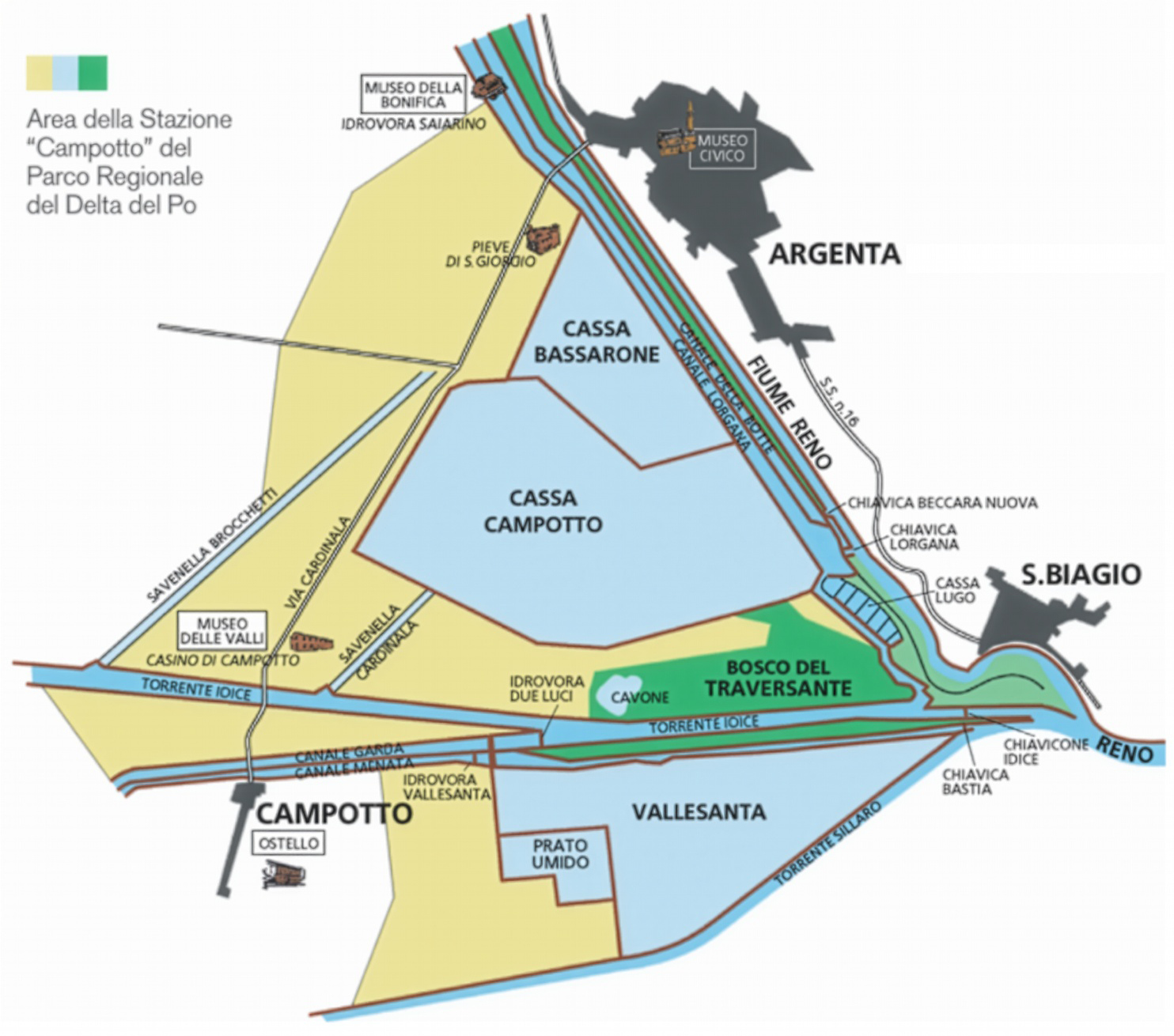
According to historical accounts, this territory was traversed by pilgrims on their way to Rome along the Via Romea Germanica (VRG) in medieval times. The route was identified by Abbot Albert from Stade (Germany) in 1236 as the best route to Rome from Northern Europe, as documented in his diary. The entire route traverses over 2000 kilometres: 1.092 km in Germany, 83 km in Austria, and 1.046 km through six Italian regions and 119 municipalities. The enhancement and promotion activities carried out by volunteer associations in the three countries led to its recognition in 2020 as a Cultural Route of the Council of Europe3, highlighting its role as a historical communication axis and contribution to the cultural unity of Europe through the centuries.
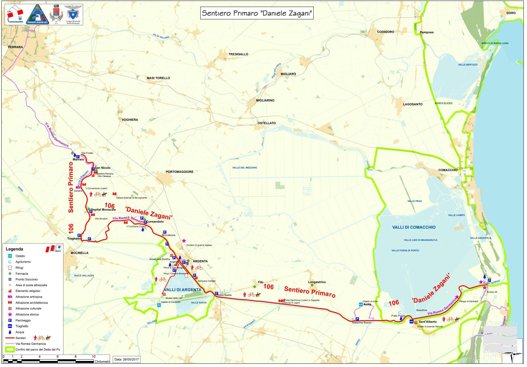
The VRG route, particularly the stretch between Ferrara and Ravenna, follows the ancient course of the Po di Primaro River. In the Middle Ages, pilgrims could combine walking with navigation on the river and other small canals to cross this region, known in those days as the “pianura liquida” (liquid plane) (Stopani 2019). Nowadays, this stretch is known by locals as the “Percorso Primaro” (Primaro Trail) (Fig. 2), running along the embankment of the old river (now mainly the Reno River) and constituting a solid element of territorial identity due to Argenta’s bond with it.
4. Materials and Methods
We use a qualitative case study approach (Baxter 2021) to explore the different perceptions, current uses, and perspective views associated with this heritage landscape. Fieldwork in the Argenta Municipality took place between 2022 and 2023. It involved multiple methods and sources of information, including participant observation, audio-visual and written material collection, focus groups, semi-structured interviews, and informal conversations with community members. Multi-method case study approaches are appropriate for investigating multi-stakeholder representations, practices, and relationships (Banini 2017) and have been extensively used to understand “perceptive and affective mechanisms defining and influencing interactions” (Meneghello 2021, 14) as in this case. The triangulation of the information collected through different data sources limited personal and methodological biases (Decrop 1999).
Despite drawing from a more comprehensive set of research data collected throughout the rurAllure project lifespan, the results of the present paper mainly draw from the data gathered through 24 semi-structured interviews: 14 with local actors and eight with supra-local actors (see Tab. 1 and Tab. 2). The respondents were selected through purposeful sampling (Patton 1990) since we were interested in those stakeholders involved in projects around the Primaro Trail and those having a stake (directly or indirectly) in its future development. These included representatives from local government, tourism businesses, local associations, public-private consortia, regional tourism agencies, and academic institutions. The direct contacts were complemented using the snowballing sampling technique, allowing us to reach other relevant actors.
| Local Actors Code |
Type of Organization | Duration (h:min:sec) | Number of pages | Number of words |
|---|---|---|---|---|
| LA1 | Eco-museum | 00:31:39 | 6 | 3871 |
| LA2 | Municipality | 00:45:00 | 8 | 5133 |
| LA3 | Eco-museum | 01:02:47 | 13 | 8992 |
| LA4 | Tourism service provider | 00:51:15 | 10 | 7097 |
| LA5 | Eco-museum | 00:19:34 | 5 | 3023 |
| LA6 | Municipality | 00:06:30 | 2 | 1008 |
| LA7 | Municipality | 00:16:45 | 5 | 2629 |
| LA8 | Tourism service provider | 00:35:22 | 9 | 5325 |
| LA9 | NGO | 00:55:58 | 10 | 6617 |
| LA10 | Tourism service provider | 00:22:48 | 5 | 3251 |
| LA11 | NGO | 01:10:51 | 11 | 7567 |
| LA12 | Catholic Church | 00:31:45 | 7 | 4051 |
| LA13 | NGO | 00:48:03 | 9 | 6033 |
| LA14 | Tourism service provider | 01:23:38 | 15 | 10617 |
| Total | 9:41:55 | 115 | 75214 |
| External Actors Code |
Type of Organization | Duration (h:min:sec) | Number of pages | Number of words |
|---|---|---|---|---|
| EA1 (1st interview) | NGO | 00:56:19 | 12 | 8372 |
| EA1 (2nd interview) | 00:53:11 | 10 | 7302 | |
| EA2 | Tourism sector (private) | 00:49:03 | 11 | 7982 |
| EA3 | Po Delta Regional Park (Emilia-Romagna) | 00:36:30 | 8 | 5128 |
| EA4 (1st interview) | Tourism sector (public) | 00:18:33 | 4 | 2324 |
| EA4 (2nd interview) | 00:37:54 | 8 | 4899 | |
| EA5 | Tourism sector (public) | 00:36:12 | 7 | 4279 |
| EA6 | Local Action Group | 00:26:08 | 6 | 3683 |
| EA7 | NGO | 00:40:49 | 8 | 5394 |
| EA8 | Research consultants (Academia) | 00:57:49 | 9 | 6667 |
| Total | 6:52:28 | 83 | 56030 |
The interviews lasted, on average, 40 minutes and ranged from 20 to 80 minutes. They were conducted in Italian by the first author. Most of the interviews were face-to-face, and ten were held in Argenta, in the participants’ standard settings or a meeting place mutually arranged, such as the multi-purpose cultural centre in Argenta. Two were conducted in Ferrara, and the remaining eight were video calls made using Zoom, which is particularly useful for reaching participants in other cities. An interview protocol was used, including standard leading questions; however, specific topics were adjusted to meet the target audience, their roles, and responsibilities. For instance, the more personal feelings and opinions regarding the Primaro River and trail were asked to local actors and not to supra-local actors who did not have such a close relation with that landscape. All interviews were audio-recorded with the permission of the participants and fully transcribed. Overall, we conducted 15 hours of interviews.
Qualitative content analysis was performed (Miles, Huberman 1994) by following a process of digital data coding using NVivo 14 to organise and reduce the amount of data collected. Following a directed content analysis approach (Hsieh, Shannon 2005), we developed a preliminary list of codes derived from the research aims and the literature on the slow mobility-heritage landscape nexus. To this end, the interview questions were used as a “rough template” (O’Dwyer 2004) to generate these preliminary codes, while new codes emerged inductively as the analysis of transcripts proceeded. Coding was done in Italian by the first author, who is functionally bilingual in Italian and English. Fifty-two codes were developed and grouped under six main themes to address the research questions. Both authors analysed the resulting codes and themes to discuss and verify interpretations, identify patterns and relations, and ensure conceptual equivalence between the data collected in Italian and its English translation for the Results section. The results from the interviews are discussed in an aggregated manner, using (when relevant) verbatim quotes in Italian, maintaining multilingualism to allow the readers to hear the interviewees’ voices (O’Dwyer 2004) as well as to avoid the loss of significance in the translation process (Mangen 1999). However, the English translation of these quotes is provided as a footnote.
5. Results and Discussion
In this section, we discuss the data collected through the interviews with local and supra-local actors that help us address our research question on the perceptions, uses, and perspectives of the Primaro trail. To do so, we use three analytical categories:
– Past: referring to the history, feelings, and memories related to the river, the trail, and the territory.
– Present: current perceptions, uses, and projects regarding the trail.
– Future: vision, aspirations, and expectations for the trail and territory.
This approach, integrating a timeframe perspective in the analysis of collected data, will allow us to better discuss the negotiation process between mobility and heritagisation of the Primaro trail.
5.1. Past (History, Feelings, Memories)
The inhabitants of Argenta perceive the Po di Primaro River as an essential element of territorial identity. The vicissitudes this territory has experienced through centuries are directly linked to its landscape’s transformations by the constant negotiation between man and nature to allow life in these marshlands. Even if the Primaro River has gradually silted up and the waters from the Reno River have been placed in its riverbed more than two centuries ago, the river has left a mark in people’s memories. In fact, for many locals, the Reno River is still called Po:
io quando ero un bambino pensavo che i miei genitori forse ignoravano i nomi dei fiumi, perché quando si andava di là dal Reno, loro […] in dialetto dicevano andiamo di là dal Po (LA1)4.
The physical mark of the river in the territory can also be perceived. Via Matteotti, for example, cutting the centre of Argenta, used to be the original riverbed, that was pushed further away when the Reno was placed into the Primaro riverbed to avoid the danger of flooding (LA1, LA2).
The Primaro trail runs along the Reno embankment. It is an essential landmark of this territory, being probably the highest embankment in Italy (LA9), built manually at the end of the XVIII century by the extraordinary work of the “scarriolanti” (wheel-barrow workers). The importance of the trail is also given by the fact that it connects the active delta of the Po River (which has been artificially moved northwards) with the historic delta, which used to be in this area centuries ago (EA3). However, the awareness of the close relation of Argenta with water is slowly being lost by the new generations that did not experience this transformation:
la gente in effetti, a parte alcuni, non ricorda più questo legame che non è solo un legame naturalistico, visto che è un parco naturale, ma è anche un legame storico, culturale, antropologico, che però si sta perdendo in effetti, e quindi quel percorso lì secondo me ci può aiutare a tenere un po’ in vita questo piccolo legame (EA3)5.
Finally, the memories of several local actors (LA2, LA4, LA8, LA11, LA13) are attached to the visionary project6 led by the Italian Alpine Club (CAI) and the Municipality of Argenta in the 1990s to enhance the old riverbed by transforming it into a cyclable and walkable trail, even navigable in certain parts, linking Ferrara to Ravenna. The trail is now an official CAI trail (number 106) dedicated to Daniele Zagani, a late club member remembered as the project’s founding father.
5.2. Present (Current Perceptions, Uses, Projects)
The current perceptions and uses of the Primaro Trail can be summarised in three main ways: a) a community infrastructure, b) a tourist infrastructure, and c) a water management/ protected area infrastructure.
a) Primaro Trail as Community Infrastructure
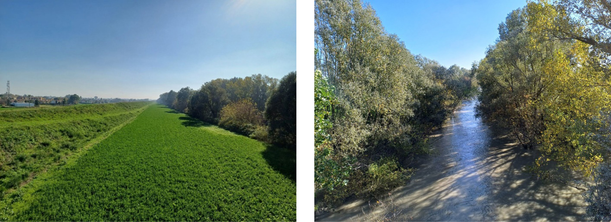
For Argenta’s inhabitants, the Primaro trail is mainly perceived as a place for strolling on the weekends or practice exercise, especially the areas located near the San Giorgio parish and the Valle Santa wetlands (Fig. 1), which are accessible to the public despite being within the limits of the Po Delta Park. However, the Reno River is not easily accessible, and the high embankment, together with the vegetation that grows along it (Fig. 3), acts as a barrier to access the river visually and physically. In the past, locals would swim in the river (LA2, LA4), but at present, some inhabitants have never had access to it (EA1).
This aspect of the embankment, perceived as a barrier between the realm of man (the Argenta city) and the realm of nature (the Po Delta Park), has been the object of several initiatives led by the Municipality, where the Primaro trail is considered the central element to recover the bond of citizens with the territory. Recent projects in collaboration with local and supra-local actors experimented with new methodologies for citizens’ participation using arts, such as theatre plays, walking performances, open assemblies in the middle of the Po Delta Park forest, etc. The aim was to regain this connection with the river and Argenta wetlands, understand its fragility, negotiate new ways for dwelling in this territory, and balance conservation, water management, and recreation uses (EA1, EA3, LA7).
[…]si sta cercando ultimamente di recuperare anche un po’ il rapporto con l’abitato di Argenta […] Cioè vedere qual è la relazione tra Argenta paese e il fiume e non soltanto tra il fiume e le valli, tra il fiume e il mare. Questo è un segno, insomma, un segno positivo (LA2)7.
The initiative to launch a Regional Observatory of the Argenta Landscape, born as a spin-off of the “Primaro trail: community infrastructure” project8, will have the Primaro River and trail as a backbone. “Il primaro è il collegamento dei nostri paesaggi, quindi sarà sempre protagonista” (LA7)9. Once constituted, this observatory will join the Emilia-Romagna network of regional observatories, formed by local governments and territorial actors interested in enhancing their landscape.
Since the Primaro trail is the only infrastructure that holds together almost all hamlets of the municipality, several actors (LA3, LA5, LA9, LA13) perceive it as an opportunity to gain a greater sense of belonging to Argenta and contribute to building the identity of the place, not an easy task in a territory spread along thirteen hamlets, bordering three provinces and speaking four dialects.
Comunque diciamo che effettivamente negli ultimi vent’anni ci sentiamo molto più parte del comune di Argenta, quindi sì, il fiume, l’argine diciamo, che è sempre stato lì […] è veramente frequentato in tutto il suo percorso, quindi ha contribuito diciamo ad unire.. ad unirci di più (LA9)10.
In this sense, the internal mobility aspect is highlighted, as the trail allows the smaller hamlets to reach Argenta using a soft mobility infrastructure (LA6). Indeed, investments thanks to European and/or national funding have been devoted to improving the physical infrastructure (LA7), namely the maintenance of the trail along the stretches near the main town of Argenta.
b) Primaro Trail as Tourist Infrastructure
The second crucial use recognised for the trail concerns its tourist potential as a slow mobility infrastructure, able to cater to the growing demand for outdoor tourism experiences, such as biking or walking tourism, becoming an opportunity for local development. Local actors recognised this tourist potential only a short time ago; this is because tourism was not among the main economic activities of Argenta, which were based on agriculture and construction, activities that have largely reduced their contribution to the local economy (LA13).
Several actors acknowledged a “cycling vocation” to this territory (LA7, LA11, LA13, EA2, EA6), being a completely flat land, and the Primaro trail as an axis connecting Argenta with two important destinations such as Ferrara and Ravenna. Indeed, FAR Gravel (standing for Ferrara-Argenta-Ravenna) is a cycling event launched in 2018 by local entrepreneurs to generate economic development, bringing cyclists for one weekend to the Primaro and surrounding gravel trails.
Seeking to develop further a strategy to attract this kind of tourism, the Municipality has sought advice from an academic partner, which, in 2021, proposed several actions to develop a supra-local project along the Primaro trail. As part of the considerations regarding the characteristics of a territorial project along the trail, the consultants highlighted the connecting role of the Primaro Trail, respecting two national cycling lanes: The Ven-To (680 km between Venezia and Torino) and the Adriatic Cycling Lane (820 km from northern to southern Italy). In turn, these cycling lanes enable the connection with other transnational cycling lanes from the Eurovelo11 network.
come avrai visto il Percorso Primaro oggi è una piccola parte di questo segmento, mentre invece per noi è importante che arrivi poi a collegarsi anche con Ven-To a Ferrara e con la Ciclovia Adriatica a Ravenna, in un’ottica di rete, che quindi non rimanga un segmento isolato nel Delta del Po (EA8)12.
Along these lines, the Ferrara Mobility Agency13 recently promoted an agreement among municipalities and other public and private institutions (EA2, EA3, LA6), in which they sought a commitment to develop (or maintain) cycling lanes that connect places at least at the provincial level and better yet, that are part of national or transnational circuits.
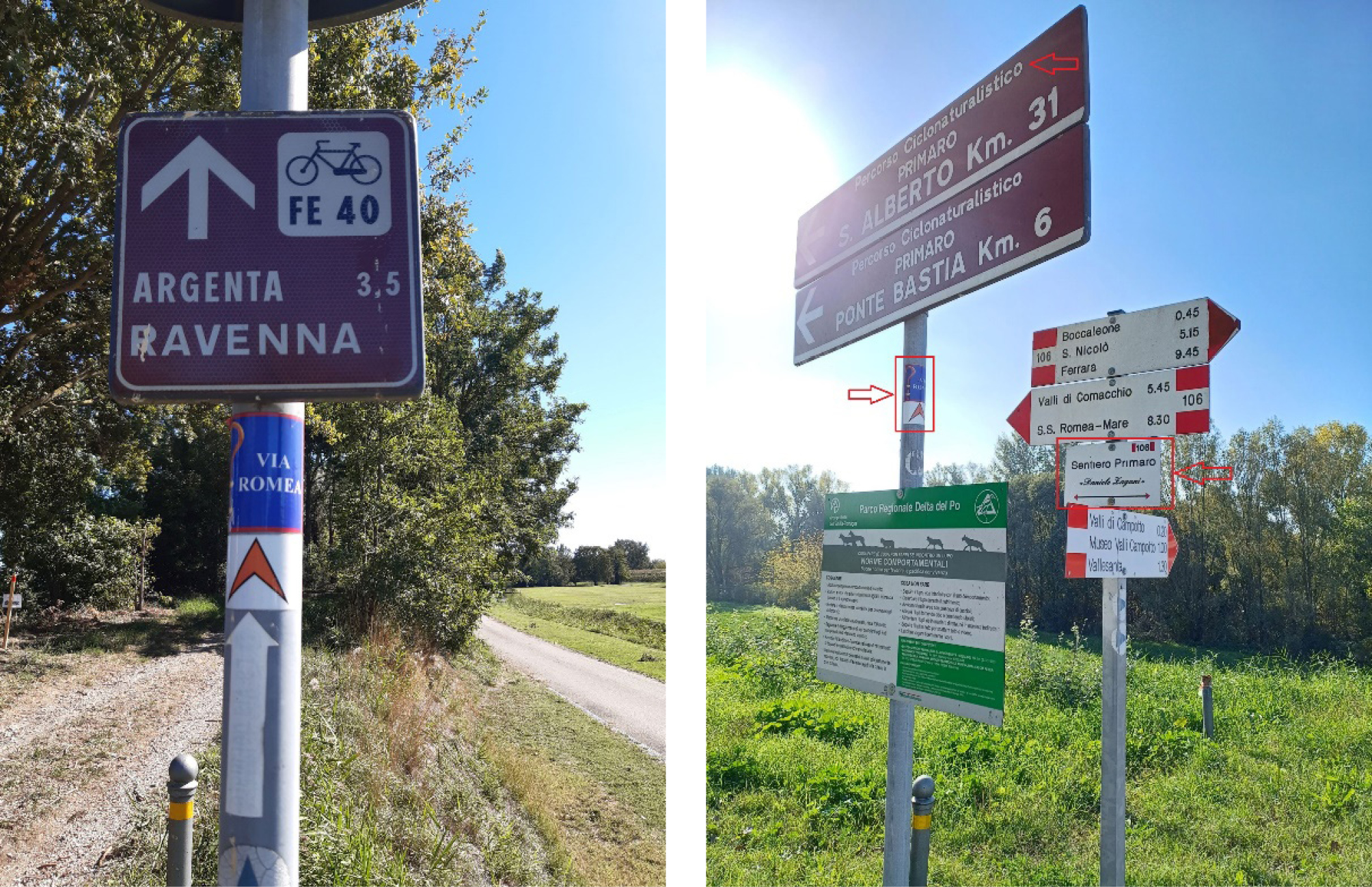
Besides these initiatives mainly addressing the slow mobility issue, the Primaro trail is part of a recently re-discovered historic pilgrimage route: The Via Romea Germanica (VRG), and as such, it is promoted by a national level association entrusted with its management, as well as the regional tourism body, as part of the Emilia-Romagna circuit of twenty-one walking trails. These supra-local actors are interested in the route’s systemic dimension and are unaware of the Primaro trail’s existence (EA4, EA7). The superposition of both trails can be seen in Figure 2 above, and the variety of signalling along the trail in Figure 4.
While the Argenta Municipality is not a member of the association managing the VRG, the Eco-museum of Argenta actively promotes the Primaro trail as a stretch from the VRG through different channels. Moreover, service providers that have come to know about this pilgrimage route have got themselves directly in contact with the association (LA4, LA8, LA14), which suggests their interest in advertising their offer in connection with this pilgrimage route and also being able to provide information to the pilgrims they host. Similarly, supra-local actors with tourism promotion and local development stakes (EA2, EA4, EA5, EA6) consider the pivotal role of service providers along the trail, supporting the tourist offer and the territorial economy.
c) Primaro Trail as Water Management Infrastructure/Protected Area
A third and critical role that emerged from the interviews and fieldwork in Argenta is that the Primaro trail is an integral part of the water management system, aside from being a slow-mobility infrastructure. Today’s landscape is very different from how it used to be before the land reclamation works. The wetlands, part of the 6th station of the Po Delta Regional Park, have been formed thanks to the artificial basins created by the drainage consortium to act as water reservoirs. These newly formed habitats resemble how the Padana plain used to look centuries ago and have enabled a variety of animals (mainly birds) and plant species to thrive, being the only freshwater wetlands within the Po Delta Park. However, these ecosystems are not self-sustaining, so man-management is fundamental for their conservation (LA1, EA3).
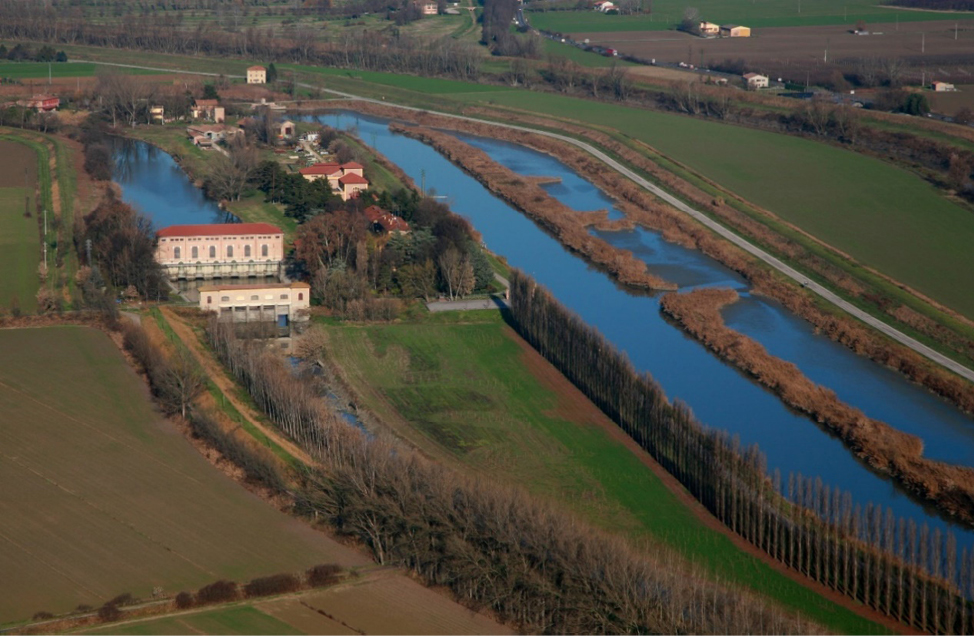
Managing this fragile landscape is crucial to reducing the risks for the local population, as it was seen in 2023 with the flooding in Emilia-Romagna, affecting cities nearby Argenta (LA1, EA1). This dramatic event highlighted that constant water management and conservation cannot be taken for granted and that the role of the several land reclamation consortia in this territory should be better understood, especially by younger generations (LA4). The role of the Eco-museum of Argenta as a collective actor involving the Land Reclamation consortium, the Po Delta Park, and the Municipality is also crucial, providing a joint interpretation of this landscape and raising awareness about its value (Figure 5).
5.3. Future (Vision, Aspirations, Expectations)
Both local and supra-local actors agree on the Primaro trail’s significant potential for Argenta in terms of community and tourist uses. Citizens’ awareness regarding the heritage value of the trail positively influences the tourist appeal of the territory, not only the protected area, which was already recognised, but also the city of Argenta and its hamlets, thanks to the recovered link with the old river and its embankment.
Quindi c’è un duplice ruolo della ciclovia Primaro: un ruolo turistico e di lunga percorrenza e un ruolo invece più locale per i cittadini, che serve anche però a rendere sostenibile nel tempo la conservazione delle valli, perché se la gente non si interessa degli ambienti che ha vicino a casa, poi finisce che nessuno se ne interessa più. E dato che sono tutti ambienti relitti e artificiali tutto sommato anche nella gestione senza attenzione da parte delle comunità locali non si mantiene nulla, perché non sono più inseriti in un ecosistema che si autosostiene (EA3)14.
All actors interviewed considered the transnational dimension critical and an opportunity to be part of a larger circuit that can bring further benefits in terms of visibility. However, most inhabitants largely ignore this dimension, and the trail is not yet perceived as a long-distance communication axis. “C’è tutta una potenzialità enorme da sviluppare tuttora perfettamente sconosciuta” (LA8)15. Some of the interviewees advocate for cancelling the local dimension in favour of a more homogeneous image, avoiding the current superposition of signalling along the same trail, which creates confusion. “Ma il Percorso Primaro deve sparire, secondo me. Bisogna cancellare il nome e dare un’identità più nazionale, più… di lunga percorrenza” (LA8)16. Therefore, the challenge is to conciliate the local and transnational aspects; one aspect should not exclude the other, as one of the interviewees points out:
La cosa molto interessante e molto complicata è riuscire a far capire che c’è questa interscalarità tra dimensione di prossimità e dimensione di vastità. Il caso del Primaro è molto interessante da questo punto di vista, perché deve tenere insieme queste due dimensioni (EA8)17
While for some actors, the trail can be used and planned for both purposes (cycling and walking), there is the concern about how slow biking is and whether projecting a cycling lane accessible “to all” (in terms of cyclists) is not excluding other users (such as walkers). A mixed-use trail for both walkers and bikers is an aspiration that some of the interviewees have mentioned:
credo che forse stiamo inquadrando la soluzione dal punto di vista sbagliato, cioè non dobbiamo asfaltarlo […] Lo dobbiamo solamente rendere più regolare. E credo che questo non darà fastidio al camminatore. […] Quindi mi viene da dire che potrebbe essere qualcosa per tutti e due, non solo per targhetizzare il ciclista, ma perché sia fruibile per pedoni, percorso ciclo-pedonale (LA13)18
This double use as a cycling and walking trail should take into consideration that the trail develops in great part within a protected area, so all these issues need to be negotiated with the Park authorities. In this sense, a proposal suggests a collaborative approach, working jointly between the Municipality and the Po Delta Park. This partnership will ensure that the stretch of the trail between Argenta and Anita is added to the Park, securing funding for the path’s maintenance in line with the conservation goals (EA3).
Finally, for many actors (LA1, EA1, EA3), this should also address the concern that the trail becomes a highway for bikes to be traversed fast without stopping and spending time in the area to appreciate it and to generate positive economic impacts.
il percorso ciclo-pedonale non può e non deve essere un’autostrada per le bici. Quello sarebbe un qualcosa che, in realtà, disequilibra questo processo di consapevolezza, di ravvicinamento (EA1)19.
fare in modo che la gente capisca che è bello andare in bicicletta ma è bello andarci piano e guardarsi intorno […] vieni nelle Valle di Comacchio, goditele. È uguale per le Valli d’Argenta, quindi un percorso fatto con calma […] permette anche di visitare ciò che si ha intorno (EA3)20.
5.4 Negotiating Uses: Between Slow Mobility and Heritage Landscape
The results discussed above show that stakeholders perceive the Primaro trail differently, recognising multiple uses and assigning specific values according to their background, role and interest towards this heritage landscape. The scale to which the stakeholder belongs also influences this perception. Overall, three main uses are recognised for the trail, namely 1) community infrastructure, 2) tourist infrastructure, and 3) water management/ protected area.
The heritagisation aspect emerges locally, while supra-local actors perceived the trail mainly as a mobility infrastructure and tourist resource. This might be explained by the fact that actors involved in tourism promotion and rural development are concerned with leveraging the existing assets of the local territories. In the words of one of these actors: “mappiamo quello che c’è, diamo consapevolezza agli operatori di quello che c’è” (EA2)21. Instead, local actors are those directly engaged in the process of identifying the elements to be considered heritage, in line with the Faro Convention and European Landscape Convention that put local communities at the centre of the heritage-making process.
Undoubtedly, the work of the Land Reclamation Consortium managing water and the Po Delta Regional Park, preserving the ecosystems formed by the artificial water basins, is complementary and paramount to maintaining the delicate equilibrium of this fragile environment. Although these water basins recreate the natural environment once present in the Padana Plain, the landscape of the Argenta Marshes is completely anthropic. Therefore, the work of the Land Reclamation Consortium to maintain these habitats should be further valued. Due to the unfortunate floods in the Emilia-Romagna region in May 2023, the level of awareness has been raised, especially among young people, about the importance of maintaining this delicate balance, every time subject to more risks due to extreme weather events and progressive changes in climate.
The current debate among local and supra-local actors mainly revolves around whether the Primaro trail should be developed as a cycling lane or a walking trail. The current municipal administration’s vision is to develop a cycling lane that is accessible to all types of users and that can become an axis that connects Argenta with Ferrara and Ravenna and, from there, with other national and European cycling lanes. This connecting element has remained imprinted in the minds of many of the interviewees as an opportunity for the tourist development of Argenta and the Po Delta territory. While all interviewees phrase the transnational dimension of the trail, this is also conditioned to whether the trail is considered a cycling lane (in that case, the benchmark becomes the Eurovelo Network) or a walking trail, in which case the VRG and the Council of Europe Cultural Routes programme is the reference point.
The multi-level dimension of the routes can be a competitive advantage that allows for local itineraries, such as the Primaro trail, to be inserted into a supra-local network, increasing their visibility and development potential (Mariotti et al. 2021). This is, in fact, the expectation behind developing these “line-based slow tourism projects” (Pileri, Moscarelli 2021), where the planning dimension concerns the line rather than the single destinations. However, these “transcalar and mobile tourist destinations” (Morazzoni, Rabbiosi 2022, 169) impact the landscape and condition its uses, favouring certain performances to the detriment of others (Cisani, Rabbiosi 2023).
We argue that a balance should be found between maintaining the local identity element and acknowledging the value of being part of a larger project. While these dimensions are not incompatible, the heritage-making process belongs to the local level, where place attachment is felt. In this case, the Primaro trail is the one charged with meanings since the identity of the place (Banini 2017) is related to the old river. The recently re-discovered VRG can be an added territorial value, but it is not rooted in the territory yet; locals do not know about it, but instead know well the history of this river and the revitalization project led by local actors since the 1990’s.
The Argenta Municipality has a pivotal role to play since it must protect this heritage landscape, ensure the correct functioning of the water management system, and involve the local community, trying to recover the bond between citizens and the landscape by promoting projects that seek to negotiate between conservation, mobility and community uses. Seeing the Reno embankment as a link between the realm of man (the city) and the realm of nature (the protected area) can help “overcome the metaphorical fence between nature and culture” (Luchetta et al. 2023, 201). Actually, the whole territory is part of the Eco-museum of Argenta, which has the mission of interpreting the territory jointly, relating the work of water management (Land Reclamation Museum), conservation of the nature oasis (Argenta Marshes), the relationship between man and nature (Marshes Museum) and the history of the city and its settlements (Civic Museum), all conditioned by the presence of water. Indeed, the Eco-museum is formed by the agreement of key stakeholders such as the Municipality, the Land Reclamation consortium, the Po Delta Regional Park, and the Ravenna Catholic Church. Precisely, these actors are those interested in the heritagisation process more than the supra-local actors, who are interested in the tourist aspects and the mobility infrastructure.
Even if the Po Delta Park goes beyond the local level, it is strongly rooted in the territory as the Argenta Marshes comprise its 6th station. The Park is willing to take up a leading role to overcome the current fragmentation since each municipality is only interested in the stretch of the trail crossing their territory, lacking an overarching vision, so the park could provide that systemic vision needed for long-distance trails. Moreover, the Park does not see the Primaro trail only as a slow-mobility infrastructure but as a heritage landscape, connecting the old Po delta and the current delta, with an important role in raising awareness among inhabitants on the conservation aspect, maintaining the balance of this fragile and anthropic landscape. The local community participation as the custodian of this landscape is a prerequisite for its protection and correct management (Sturani 2023).
Besides being a tourist infrastructure, the particularity of the Primaro trail is that it is a water management infrastructure first of all, an integral part of the drainage system still in use by the Land Reclamation Consortium, whose main purpose is to channel water and protect Argenta from flooding. Slow tourism can be an additional use, but constantly negotiating with the water management use that conditions mobility.
6. Conclusions
This paper aimed to analyse the different perceptions of local and supra-local actors associated with a particular heritage landscape and slow-mobility infrastructure: The Primaro trail in the Argenta Municipality. To do this, we employed three analytical categories: past (history and memories), present (current uses), and future (long-term vision) dimensions, which were explored through fieldwork and semi-structured interviews.
We found that the current debate mainly focuses on the mobility and connectivity aspects of the Primaro trail, namely its uses as a cycling or walking trail, while the heritagisation of this landscape is left in a secondary position. More attention should be given to the heritage value of the trail so that the debate concentrates on more than just the mobility issue, especially since the conservation of the landscape conditions mobility. The evolution of this landscape has been shaped by the presence of water, and human mobility is conditioned, now as it was in the past, by the mobilities of water (Luchetta et al. 2023). The opportunity is given to valorise this heritage, recognising the embankment as a slow-mobility infrastructure and a link to relate inhabitants with their surroundings (Pereira, Vilaca Dupin 2023). Otherwise, mobility can be compromised if this water landscape is not adequately maintained.
Considering the Primaro trail’s identity value for local inhabitants, awareness should be raised about the need to protect this fragile environment while also exploiting the opportunity to revitalise the territory thanks to its position as a communication axis with Ferrara, Ravenna, and Europe. The Primaro trail, as a tourist infrastructure, could bring back a new vitality to the riverbank, as it once had through other economic activities.
The Eco-museum of Argenta emerges as a critical actor in this negotiation between slow mobility and heritage landscape over the Primaro trail. The municipality, the Po Delta Park, and the Land Reclamation Consortium are all involved in the eco-museum, and its mission is to interpret the territory jointly. These actors must find “windows of collaboration” (Dredge 2006) to agree on a shared strategic vision for this heritage landscape.
This long-term vision should also address the governance of the Primaro trail to better balance contested uses and perspective views. Currently, several actors are involved, but no working group periodically meets to discuss these issues. An opportunity arises with the recently launched Regional Observatory of Argenta Landscape, which could be the interlocutor that moves up the heritage aspect from the local to the supra-local scale. Moreover, a supra-local actor such as the Po Delta Regional Park might be well suited for this coordination role between the municipalities, negotiating the Primaro trail mobility and heritage values.
References
Banini, T. (2017). Proposing a Theoretical Framework for Local Territorial Identities: Concepts, Questions and Pitfalls. Territorial Identity and Development, 2(2), 16-23. DOI: https://doi.org/10.23740/TID220172
Baxter, J. (2021). Case Studies in Qualitative Research. In Hay, I., Cope, M. (Eds.), Qualitative Research Methods in Human Geography (Fifth edition). Don Mills, Oxford University Press, 109-124.
Bolognesi, B. (2019). Quando Argenta era un castello. Annali online Sezione di Lettere. Supplemento 14: Rinascimento argentano. Arti, architettura, storia, archeologia, 200-225. DOI: https://doi.org/10.15160/1826-803X/2240
Bowman, M., Johannsen, D., Ohrvik, A. (2020). Reframing Pilgrimage in Northern Europe: Introduction to the Special Issue. Numen, 67(5-6), 439-452. DOI: https://doi.org/10.1163/15685276-12341597
Cisani, M., Rabbiosi, C. (2023). Exploring Tourism Slow Mobilities. In Biasiori, L., Mazzini, F., Rabbiosi, C. (Eds.). Reimagining mobilities across the humanities, 2, 156-169. DOI: https://orcid.org/0000-0002-2470-7962
Dai Prà, E., Gabellieri, N. (2022). Regione storica e umanizzata. In Gavinelli, D., Bolocan Goldstein, M. (Eds.). Regioni e regionalizzazione: Lo spazio-mondo in divenire. Milano, Pearson, 57-75.
Decrop, A. (1999). Triangulation in Qualitative Tourism Research. Tourism Management, 20(1), 157-161. DOI: https://doi.org/10.1016/S0261-5177(98)00102-2
Dredge, D. (2006). Networks, Conflict and Collaborative Communities. Journal of Sustainable Tourism, 14(6), 562-581. DOI: https://doi.org/10.2167/jost567.0
Ferrara V., Ekblom, A., Wästfelt, A. (2023). From Landscape as Heritage to Biocultural Heritage in a Landscape: The Ecological and Cultural Legacy of Millennial Land Use Practices for Future Natures. In Pettenati, G. (Ed.). Landscape as Heritage: International Critical Perspectives. Abingdon, Routledge, 80-90.
Harvey, D. (2015). Landscape and Heritage: Trajectories and Consequences. Landscape Research, 40(8), 911-924. DOI: https://doi.org/10.1080/01426397.2014.967668
Harvey, D. C., Waterton, E. (2015). Editorial: Landscapes of Heritage and Heritage Landscapes. Landscape Research, 40(8), 905-910. DOI: https://doi.org/10.1080/01426397.2015.1086563
Hsieh, H. F., Shannon, S. E. (2005). Three Approaches to Qualitative Content Analysis. Qualitative Health Research, 15(9), 1277-1288. DOI: https://doi.org/10.1177/1049732305276687
López Nores, M., Pazos Arias, J.J., Reboreda Morillo, S., Penín Romero, O. (2023). The Horizon 2020 project rurAllure. Studying ilgrimage as slow tourism, territorial development, social cohesion. La Rivista di Engramma, 204, 11-20.
Luchetta, S., Castiglioni, B., Varotto, M. (2023). Moving Dolomites: The Heritage Value of an Ordinary Mountain Landscape. In Pettenati, G. (Ed.), Landscape as heritage: International critical perspectives. Abingdon, Routledge, 194-203.
Mangen, S. (1999). Qualitative Research Methods in Cross-National Settings. International Journal of Social Research Methodology, 2(2), 109-24. DOI: https://doi.org/10.1080/136455799295087
Mariotti A. (2023). Thermal Heritage on the Ways to Rome. The Role of Knowledge for Enriching Tourism Experiences Along Three Italian Pilgrimage Ways. La Rivista di Engramma, 204, 21-34.
Mariotti, G., Camerada, M. V., Lampreu, S., Carrus, S. (2021). Vocación turística de los itinerarios religiosos y perspectivas de desarrollo territorial: El Camino de Santu Jacu en Cerdeña (Italia). Revista Galega de Economía, 30(3), 1-23. DOI: https://doi.org/10.15304/rge.30.3.7549
Meneghello, S. (2021). The Tourism–Landscape Nexus: Assessment and Insights from a Bibliographic Analysis. Land, 10(4), 417, 1-25. DOI: https://doi.org/10.3390/land10040417
Miles, M. B., Huberman, A. M. (1994). Qualitative Data Analysis: An Expanded Sourcebook. Second edition. Thousand Oaks, Sage Publications.
Morazzoni, M., Rabbiosi, C. (2022). Regione Turistica. In Gavinelli, D., Bolocan Goldstein, M. (Eds.). Regioni e regionalizzazione: Lo spazio-mondo in divenire. Milano, Pearson, 157-180.
O’Dwyer, B. (2004). Qualitative Data Analysis: Illuminating a Process for Transforming a ‘Messy’ but ‘Attractive’ ‘Nuisance’. In Humphrey, C., Lee, B. (Eds.). The Real Life Guide to Accounting Research: A Behind-the-Scenes View of Using Qualitative Research Methods. Amsterdam, Elsevier, 391-407.
Patton, M. Q. (2010). Qualitative research & evaluation methods. Third edition. Thousand Oaks, Sage Publications.
Pereira, E., Vilaca Dupin, L. (2023). Remaking a Landscape After the Trauma: The Brumadinho Dam Catastrophe and the Memorial for the Victims. In Pettenati, G. (Ed.). Landscape as Heritage: International Critical Perspectives. Abingdon, Routledge, 148-158.
Pettenati, G. (2023). Why we Need a Critical Perspective on Landscape as Heritage. In Pettenati, G. (Ed.), Landscape as Heritage: International Critical Perspectives. Abingdon, Routledge, 1-17.
Pileri, P., Moscarelli, R. (2021). From Slow Tourism to Slow Travel: An Idea for Marginal Regions. In Pileri, P., Moscarelli, R. (Eds.). Cycling & Walking for Regional Development. How Slowness Regenerates Marginal Areas. Cham, Springer Nature Switzerland, 3-16. DOI: https://doi.org/10.1007/978-3-030-44003-9_1
Progetto Primaro: Un disegno per l’ambiente (1990). Progetto di massima per la valorizzazione ed organizzazione di un percorso lungo il Po di Primaro da Ferrara al mare. Comune di Argenta, Club Alpino Italiano (Sezione di Argenta), Pro LOCO di Argenta.
Stopani, R. (2019). Vie Romee, Dall’alto medievale Via Francigena alla Pluralità di Percorsi Romipeti del Basso Medioevo. Fano, Centri Studi Romei.
Sturani, M. L. (2023). Landscape as Heritage in Museums: A Critical Appraisal of Past and Present Experiences. In Pettenati, G. (Ed.). Landscape as Heritage: International Critical Perspectives. Abingdon, Routledge, 289-300.
1 COM 2010, 352 final: “Europe, the world’s No 1 tourist destination – a new political framework for tourism in Europe
4 When I was a child, I thought that my parents probably didn’t know the names of the rivers, because when we went across the Reno, they […] used to say in dialect let’s go across the Po.
5 People in fact, apart from a few, no longer remember this bond, which is not only a naturalistic bond, since it is a natural park, but also a historical, cultural, anthropological bond, which is in fact being lost, and so that path there, in my opinion, can help us keep this little bond alive.
6 Progetto Primaro: un disegno per l’ambiente. Progetto di massima per la valorizzazione ed organizzazione di un percorso lungo il Po di Primaro da Ferrara al mare.
7 […] recently we have been trying to recover a bit the relationship with the town of Argenta […] That is, to see what the relationship is between the town of Argenta and the river, and not just between the river and the marshes, between the river and the sea. This is a sign, in short, a positive sign.
8 https://partecipazione.regione.emilia-romagna.it/la-legge-e-il-bando/schede-progetti/bando-2021/percorso-primaro-infrastruttura-di-comunita
9 The Primaro connects our landscapes, so it will always be the protagonist.
10 In any case, let’s say that in the last twenty years we have actually felt much more part of the municipality of Argenta, so yes, the river, the embankment, let’s say, which has always been there […] is really frequented throughout its course, so it has contributed, let’s say, to unite us more.
12 as you may have seen, the Primaro trail today is a small part of this segment, while for us it is important that it also connects with Vento in Ferrara and the Adriatic cycle route in Ravenna, in a network perspective, so that it does not remain an isolated segment in the Po Delta.
14 So there is a dual role for the Primaro cycling trail: a touristic and long-distance role and a more local role for citizens, which also serves, however, to make the conservation of the valleys sustainable over time, because if people do not take an interest in the environments they have close to home, then no one will take an interest in them. And since they are all relict and artificial environments, without the attention from local communities to its management nothing is maintained, because they are no longer part of a self-sustaining ecosystem.
15 There is a huge potential to be developed that is still completely unknown.
16 But the Primaro trail has to disappear, in my opinion. The name must be erased and a more national, long-distance identity should be given.
17 The very interesting and very complicated thing is to be able to make people understand that there is this interscalarity between the dimension of proximity and the dimension of vastness. The case of the Primaro is very interesting from this point of view, because it has to hold together these two dimensions.
18 I think maybe we are framing the solution from the wrong point of view, that is, we don’t have to asphalt it […] We just have to make it more even. And I think that won’t bother the walker. […] So it seems to me that it could be something for both, not just to target the cyclist, but for it to be usable for pedestrians too, a cycle-pedestrian path.
19 the cycle lane cannot and must not be a highway for bicycles. That would be something that actually unbalances this process of awareness, of rapprochement.
20 make people understand that it’s nice to ride a bike but it’s nice to ride slowly and look around […] you come to the Comacchio Valleys, enjoy them. It’s the same for the Argenta Valleys, so a journey done slowly […] also allows you to visit what’s around you.
21 we map what is there, we make operators more aware of what is there.